Geolocate

Honea Path topographic map

Click on the map to display elevation.

About this map

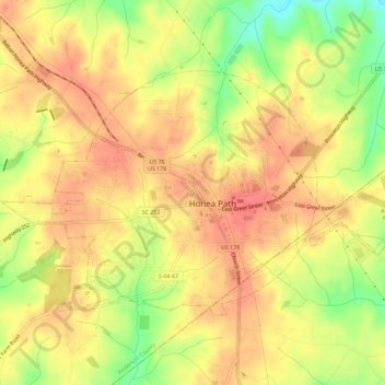
Name: Honea Path topographic map, elevation, terrain.

Location: Honea Path, Anderson County, South Carolina, United States (34.43272 -82.42316 34.46289 -82.36554)

Average elevation: 758 ft

Minimum elevation: 630 ft

Maximum elevation: 827 ft

Anderson County trails, hiking, mountain biking, running and outdoor activities

Other topographic maps

Click on a map to view its topography, its elevation and its terrain.

New Light

United States > South Carolina > Anderson County

Average elevation: 755 ft

Townville

United States > South Carolina > Anderson County

Average elevation: 751 ft

Campbell

United States > South Carolina > Anderson County

Average elevation: 755 ft

Starr

United States > South Carolina > Anderson County

Average elevation: 745 ft

Lakefront

United States > South Carolina > Anderson County

Average elevation: 705 ft

Gear up for your next adventure:

😴Insulated Sleeping Pads - Compact and warm pads for high-elevation camping
🥇GPS Hiking Watch - Multi‑sport GPS watch with navigation and trail tracking
🚁Photography Drones - Capture stunning aerial views of landforms and topography
🧺Microfiber Travel Towels - Compact and fast-drying towels for trail use
🧥Men's Rain Shells - Premium waterproof and breathable jackets for mountain weather

As an Amazon Associate, this site earns from qualifying purchases at no extra cost to you.