
Houston topographic map
Click on the map to display elevation.
Houston
The Houston Hikers' Society provides website where trail information, maps, photos and driving directions can be accessed. The Morice Mountain Nordic Ski Club is a volunteer non-profit society. The MMNSC is responsible for all developments and trail grooming as well as maintenance of the facilities, and for trail users' fee collections. The ski trails are situated 8 km (5 mi) south of Houston on Buck Flats Road. Skiing enthusiasts are able to explore over 45 km (28 mi) of challenging and beginner trails covering a rolling topography around Silverthorne Lake.
About this map
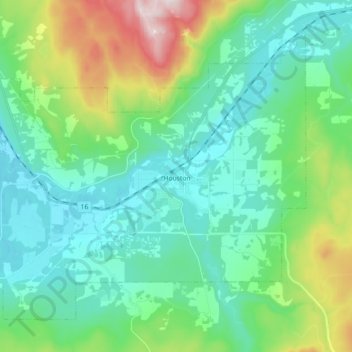
Name: Houston topographic map, elevation, terrain.
Average elevation: 2,388 ft
Minimum elevation: 1,883 ft
Maximum elevation: 4,052 ft
Other topographic maps
Click on a map to view its topography, its elevation and its terrain.
Rose Lake
Canada > British Columbia > Regional District of Bulkley-Nechako > Area B (Broman Lake/Sheraton)
Average elevation: 2,543 ft
Bulkley Valley
Canada > British Columbia > Regional District of Bulkley-Nechako
Average elevation: 3,445 ft
Silver Creek
Canada > British Columbia > Regional District of Bulkley-Nechako > Area C (Stuart Lake/Omineca Valley)
Average elevation: 3,297 ft
Grassy Plains
Canada > British Columbia > Regional District of Bulkley-Nechako > Area E (Ootsa Lake/François Lake)
Average elevation: 2,989 ft
Fort Fraser
Canada > British Columbia > Regional District of Bulkley-Nechako > Area D (Endako/Fort Fraser)
Average elevation: 2,402 ft
Nechako Plateau
Canada > British Columbia > Regional District of Bulkley-Nechako > Area G (Morice Valley/Babine Valley)
Average elevation: 3,166 ft
Mount Germansen
Canada > British Columbia > Regional District of Bulkley-Nechako > Area C (Stuart Lake/Omineca Valley)
Average elevation: 5,581 ft
Mount Milligan
Canada > British Columbia > Regional District of Bulkley-Nechako > Area C (Stuart Lake/Omineca Valley)
Average elevation: 3,934 ft
Donald Lake
Canada > British Columbia > Regional District of Bulkley-Nechako > Area C (Stuart Lake/Omineca Valley)
Average elevation: 2,651 ft
Mount Ogden
Canada > British Columbia > Regional District of Bulkley-Nechako > Area C (Stuart Lake/Omineca Valley)
Average elevation: 5,295 ft
Emmett Lake
Canada > British Columbia > Regional District of Bulkley-Nechako > Area D (Endako/Fort Fraser)
Average elevation: 3,169 ft
Smaby Peak
Canada > British Columbia > Regional District of Bulkley-Nechako > Area E (Ootsa Lake/François Lake)
Average elevation: 5,709 ft
Skeena Mountains
Canada > British Columbia > Regional District of Bulkley-Nechako > Area C (Stuart Lake/Omineca Valley)
Average elevation: 4,393 ft
Smith Island
Canada > British Columbia > Regional District of Bulkley-Nechako > Area C (Stuart Lake/Omineca Valley)
Average elevation: 2,907 ft
Fort Fraser
Canada > British Columbia > Regional District of Bulkley-Nechako > Area D (Endako/Fort Fraser)
Average elevation: 2,402 ft
Old Fort
Canada > British Columbia > Regional District of Bulkley-Nechako > Area G (Morice Valley/Babine Valley)
Average elevation: 2,572 ft
Omineca Mountains
Canada > British Columbia > Regional District of Bulkley-Nechako > Area C (Stuart Lake/Omineca Valley)
Average elevation: 3,015 ft
St. Mary Lake
Canada > British Columbia > Regional District of Bulkley-Nechako > Area C (Stuart Lake/Omineca Valley)
Average elevation: 2,648 ft
Babine Range
Canada > British Columbia > Regional District of Bulkley-Nechako > Area A (Hudson Bay Mountain)
Average elevation: 6,211 ft
Smoke Mountain
Canada > British Columbia > Regional District of Bulkley-Nechako > Area E (Ootsa Lake/François Lake)
Average elevation: 4,839 ft