
Make a donation
Gear up for your next adventure:
As an Amazon Associate, this site earns from qualifying purchases at no extra cost to you.
Alula District topographic map
Click on the map to display elevation.
Make a donation
Gear up for your next adventure:
As an Amazon Associate, this site earns from qualifying purchases at no extra cost to you.
About this map
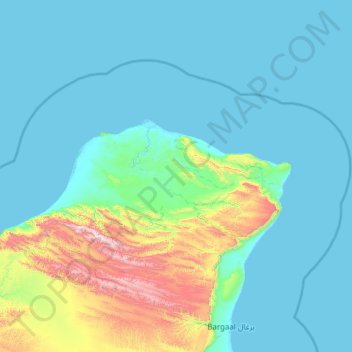
Name: Alula District topographic map, elevation, terrain.
Location: Alula District, Bari, Puntland, Somalia (11.40000 50.27197 12.18891 51.49243)
Average elevation: 597 ft
Minimum elevation: -7 ft
Maximum elevation: 4,734 ft
Make a donation
Gear up for your next adventure:
As an Amazon Associate, this site earns from qualifying purchases at no extra cost to you.
Other topographic maps
Click on a map to view its topography, its elevation and its terrain.
Make a donation
Gear up for your next adventure:
As an Amazon Associate, this site earns from qualifying purchases at no extra cost to you.
Somali Peninsula
Somalia > Bari > Qardho District
In Somalia and Somaliland, there is not much seasonal variation in climate. Hot conditions prevail year-round along with periodic monsoon winds and irregular rainfall. Mean daily maximum temperatures range from 28 to 43 °C (82 to 109 °F), except at higher elevations along the eastern seaboard, where the…
Average elevation: 2,756 ft