
Barnstable topographic map
Click on the map to display elevation.
About this map
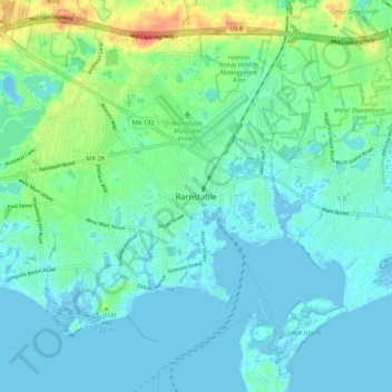
Name: Barnstable topographic map, elevation, terrain.
Location: Barnstable, Barnstable County, Massachusetts, United States (41.61398 -70.32196 41.69398 -70.24196)
Average elevation: 33 ft
Minimum elevation: -13 ft
Maximum elevation: 141 ft
Barnstable County trails, hiking, mountain biking, running and outdoor activities
Other topographic maps
Click on a map to view its topography, its elevation and its terrain.
Cliffside Estates
United States > Massachusetts > Barnstable County > Bourne > Sagamore Highlands
Average elevation: 59 ft
Bog Pond Cr, Waquoit
United States > Massachusetts > Barnstable County > Falmouth
Average elevation: 23 ft
Santuit Pond
United States > Massachusetts > Barnstable County > Mashpee > Mashpee Neck > Pine Tree Corner
Average elevation: 49 ft
Sandwich Fish Hatchery
United States > Massachusetts > Barnstable County > Sandwich
Average elevation: 75 ft
Peters Pond
United States > Massachusetts > Barnstable County > Sandwich > Forestdale
Average elevation: 131 ft