
Barnstable topographic map
Click on the map to display elevation.
About this map
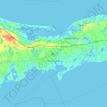
Name: Barnstable topographic map, elevation, terrain.
Location: Barnstable, Barnstable County, Massachusetts, United States (41.54852 -70.46760 41.79328 -70.25963)
Average elevation: 23 ft
Minimum elevation: -20 ft
Maximum elevation: 259 ft
Barnstable County trails, hiking, mountain biking, running and outdoor activities
Other topographic maps
Click on a map to view its topography, its elevation and its terrain.
Town of Barnstable Public Lands
United States > Massachusetts > Barnstable County > Barnstable > West Barnstable
Average elevation: 3 ft
Cliffside Estates
United States > Massachusetts > Barnstable County > Bourne > Sagamore Highlands
Average elevation: 59 ft
Marstons Mills
United States > Massachusetts > Barnstable County > Marstons Mills
Average elevation: 56 ft
Mashpee Neck
United States > Massachusetts > Barnstable County > Mashpee > Mashpee Neck
Average elevation: 33 ft
South Chatham
United States > Massachusetts > Barnstable County > Chatham > South Chatham
Average elevation: 30 ft
Bog Pond Cr, Waquoit
United States > Massachusetts > Barnstable County > Falmouth
Average elevation: 23 ft
Santuit Pond
United States > Massachusetts > Barnstable County > Mashpee > Mashpee Neck > Pine Tree Corner
Average elevation: 49 ft
Sandwich Fish Hatchery
United States > Massachusetts > Barnstable County > Sandwich
Average elevation: 75 ft
Peters Pond
United States > Massachusetts > Barnstable County > Sandwich > Forestdale
Average elevation: 131 ft
West Hyannisport
United States > Massachusetts > Barnstable County > Barnstable > Hyannis
Average elevation: 16 ft
Falmouth Heights
United States > Massachusetts > Barnstable County > Falmouth
Average elevation: 13 ft
West Barnstable
United States > Massachusetts > Barnstable County > West Barnstable
Average elevation: 49 ft
Saconesset Hills
United States > Massachusetts > Barnstable County > Falmouth > Saconesset Hills
Average elevation: 33 ft
Red Brook Pond Dam
United States > Massachusetts > Barnstable County > Bourne
Average elevation: 39 ft