
Karmiel topographic map
Click on the map to display elevation.
Karmiel
Karmiel is located on the Acre–Safed road, on the northern edge of the Lower Galilee. It lies in the Beit HaKerem Valley and its elevation is 330 m (1,082.68 ft). The Hilazon Stream passes slightly to the south of Karmiel. Its tributaries, the Shezor and Shagor Streams pass through Karmiel on the east and north, respectively. Karmiel sits on the Shagor mountain range, which stretches from Mount Hazon in the east (584 m (1,916.01 ft), next to Maghar) to Mount Gilon in the west (367 m (1,204.07 ft), at Gilon). Western Karmiel was built on the Karmi (362 m) and Makosh (315 m) mountains. Work on a new railway line linking Haifa and Karmiel began in 2011 and opened in 2017.
About this map
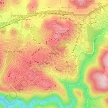
Name: Karmiel topographic map, elevation, terrain.
Location: Karmiel, Acre Subdistrict, North District, Israel (32.89765 35.26634 32.92434 35.30918)
Average elevation: 791 ft
Minimum elevation: 249 ft
Maximum elevation: 1,129 ft
Other topographic maps
Click on a map to view its topography, its elevation and its terrain.
Sea of Galilee
After five years of drought as of 2018, Sea of Galilee is expected to get to the black line. The black elevation line is the lowest depth from which irreversible damage begins and no water can be pumped out any more. Israel Oceanographic and Limnological Research describes it as "The black line marks −214.87…
Average elevation: -220 ft
2236 Mt. Hermon
Israel > North District > Golan Regional Council
Mount Hermon (Arabic: جبل الشيخ or جبل حرمون / ALA-LC: Jabal al-Shaykh ('Mountain of the Sheikh') or Jabal Haramun; Hebrew: הַר חֶרְמוֹן, Har Ḥermōn) is a mountain cluster constituting the southern end of the Anti-Lebanon mountain range. Its summit straddles the border between…
Average elevation: 6,614 ft
Golan Heights
The Golan Heights is a basaltic plateau in southwestern Syria, extending about 44 miles (71 km) from north to south and about 27 miles (43 km) from east to west at its widest point, covering approximately 444 square miles (1,150 square km). The terrain is characterized by its hilly and elevated nature, with an…
Average elevation: 1,719 ft
Nazareth
As of the early 1990s, no city plans drafted by Nazareth Municipality have been approved by the government (both the British Mandate and later Israel) since 1942. This has left many people in Nazareth who vote in the city's municipal elections and receive services from its municipality effectively outside of…
Average elevation: 1,175 ft
Majdal Shams
The name "Majdal Shams" originates from Aramaic, meaning: "tower of sun" in reference (possibly) to the town's elevation. Another hypothesis suggests that the town was originally called Majdal al-Sham (Majdal of Damascus) to distinguish it from the towns of al-Majdal on the Mediterranean Coast and al-Majdal on…
Average elevation: 4,042 ft
Nazareth
Israel > North District > Nazareth
As of the early 1990s, no city plans drafted by Nazareth Municipality have been approved by the government (both the British Mandate and later Israel) since 1942. This has left many people in Nazareth who vote in the city's municipal elections and receive services from its municipality effectively outside of…
Average elevation: 495 ft