
Golan Heights topographic map
Click on the map to display elevation.
Golan Heights
The Golan Heights is a basaltic plateau in southwestern Syria, extending about 44 miles (71 km) from north to south and about 27 miles (43 km) from east to west at its widest point, covering approximately 444 square miles (1,150 square km). The terrain is characterized by its hilly and elevated nature, with an average altitude of about 2,500 feet (760 meters). The region rises northward toward Mount Hermon, and slopes down to about 1,300 feet (400 meters) elevation along the Yarmouk River in the south. The northern half features steeper, more rugged topography, including the foothills of Mount Hermon, while the southern portion presents a more level plateau. The western edge is marked by a rock escarpment that drops approximately 1,600 feet (500 meters) to the Jordan River Valley and the Sea of Galilee. This varied terrain includes volcanic cones, rocky outcrops, and fertile valleys, contributing to its strategic significance and diverse ecosystems.
About this map
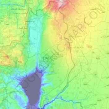
Name: Golan Heights topographic map, elevation, terrain.
Location: Golan Heights, North District, Israel (32.68213 35.61332 33.33563 35.89502)
Average elevation: 1,719 ft
Minimum elevation: -728 ft
Maximum elevation: 7,713 ft
Other topographic maps
Click on a map to view its topography, its elevation and its terrain.
2236 Mt. Hermon
Israel > North District > Golan Regional Council
Mount Hermon (Arabic: جبل الشيخ or جبل حرمون / ALA-LC: Jabal al-Shaykh ('Mountain of the Sheikh') or Jabal Haramun; Hebrew: הַר חֶרְמוֹן, Har Ḥermōn) is a mountain cluster constituting the southern end of the Anti-Lebanon mountain range. Its summit straddles the border between…
Average elevation: 6,614 ft
Tiberias
Tiberias is located on the shore of the Sea of Galilee and the western slopes of the Jordan Rift Valley overlooking the lake, in the elevation range of −200 to 200 metres (−660–660 feet). Tiberias has a climate that borders a Hot-summer Mediterranean climate (koppen Csa) and a Hot Semi-arid climate…
Average elevation: -7 ft
Nazareth
Israel > North District > Nazareth
As of the early 1990s, no city plans drafted by Nazareth Municipality have been approved by the government (both the British Mandate and later Israel) since 1942. This has left many people in Nazareth who vote in the city's municipal elections and receive services from its municipality effectively outside of…
Average elevation: 495 ft
Karmiel
Karmiel is located on the Acre–Safed road, on the northern edge of the Lower Galilee. It lies in the Beit HaKerem Valley and its elevation is 330 m (1,082.68 ft). The Hilazon Stream passes slightly to the south of Karmiel. Its tributaries, the Shezor and Shagor Streams pass through Karmiel on the east and…
Average elevation: 791 ft