
Wilmer topographic map
Interactive map
Click on the map to display elevation.
About this map
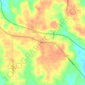
Name: Wilmer topographic map, elevation, terrain.
Location: Wilmer, Mobile County, Alabama, 36587, United States (30.80324 -88.38140 30.84324 -88.34140)
Average elevation: 220 ft
Minimum elevation: 121 ft
Maximum elevation: 276 ft
Other topographic maps
Click on a map to view its topography, its elevation and its terrain.
Dauphin Island
United States > Alabama > Mobile County
Dauphin Island, Mobile County, Alabama, 36528, United States
Average elevation: 0 ft
Dees
United States > Alabama > Mobile County
Dees, Mobile County, Alabama, United States
Average elevation: 108 ft
Semmes
United States > Alabama > Mobile County
Semmes, Mobile County, Alabama, 36663, United States
Average elevation: 194 ft
Dauphin Island
United States > Alabama > Mobile County
Dauphin Island, Mobile County, Alabama, 36528, United States
Average elevation: 0 ft
Mobile
United States > Alabama > Mobile County
Mobile, Mobile County, Alabama, United States
Average elevation: 52 ft
Regency
United States > Alabama > Mobile County > Mobile
Regency, Mobile, Mobile County, Alabama, 36609, United States
Average elevation: 174 ft
Grand Bay
United States > Alabama > Mobile County
Grand Bay, Mobile County, Alabama, United States
Average elevation: 72 ft
Chunchula
United States > Alabama > Mobile County
Chunchula, Mobile County, Alabama, 36521, United States
Average elevation: 118 ft
Cambridge Estates
United States > Alabama > Mobile County > Mobile
Cambridge Estates, Mobile, Mobile County, Alabama, 36609, United States
Average elevation: 141 ft
Mobile Bay
United States > Alabama > Mobile County
Mobile Bay, Mobile County, Alabama, 36615, United States
Average elevation: 39 ft
Wildwood Heights
United States > Alabama > Mobile County > Mobile
Wildwood Heights, Mobile, Mobile County, Alabama, 36609, United States
Average elevation: 161 ft
Neely
United States > Alabama > Mobile County > Prichard
Neely, Prichard, Mobile County, Alabama, 36617, United States
Average elevation: 43 ft
Theodore
United States > Alabama > Mobile County
Theodore, Mobile County, Alabama, 36582, United States
Average elevation: 79 ft
Citronelle
United States > Alabama > Mobile County > Citronelle
Citronelle, Mobile County, Alabama, 36522, United States
Average elevation: 230 ft
Cloverdale
United States > Alabama > Mobile County
Cloverdale, Mobile County, Alabama, United States
Average elevation: 43 ft
Saraland
United States > Alabama > Mobile County
Saraland, Mobile County, Alabama, 36571, United States
Average elevation: 46 ft
Spanish River
United States > Alabama > Mobile County > Mobile > Spanish Fort
Spanish River, Spanish Fort, Mobile, Mobile County, Alabama, 36577, United States
Average elevation: 10 ft
Park Forest
United States > Alabama > Mobile County > Mobile > Park Forest
Park Forest, Mobile, Mobile County, Alabama, 36688, United States
Average elevation: 177 ft
Todd Acres
United States > Alabama > Mobile County > Mobile > Todd Acres
Todd Acres, Mobile, Mobile County, Alabama, United States
Average elevation: 20 ft
Coden
United States > Alabama > Mobile County
Coden, Mobile County, Alabama, 86082, United States
Average elevation: 10 ft
Pennsylvania
United States > Alabama > Mobile County > Satsuma > Pennsylvania
Pennsylvania, Satsuma, Mobile County, Alabama, 36539, United States
Average elevation: 23 ft