
Make a donation
Gear up for your next adventure:
As an Amazon Associate, this site earns from qualifying purchases at no extra cost to you.
Aquila topographic map
Click on the map to display elevation.
Make a donation
Gear up for your next adventure:
As an Amazon Associate, this site earns from qualifying purchases at no extra cost to you.
Aquila
Aquila (Spanish pronunciation: [aˈkila]) is a town in the southwest part of the Mexican state of Michoacán. It is the municipal seat for the municipality of Aquila. It is 23 mi/43 km southeast of Tecoman. Its population was 1,915 in 2002. It is located at Latitude: 18°35'N Longitude: 103°31'W and at elevation 989 ft/510 m. It has harsh terrain. Agriculture consists of small farming, mainly for subsistence. There is one paved road south to Mexico Highway 200 (5 mi/11 km away).
Make a donation
Gear up for your next adventure:
As an Amazon Associate, this site earns from qualifying purchases at no extra cost to you.
About this map
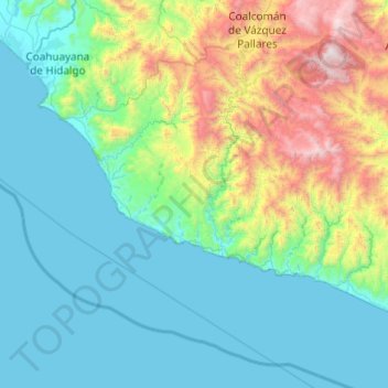
Name: Aquila topographic map, elevation, terrain.
Location: Aquila, Michoacán, Mexico (18.08332 -103.71189 18.68546 -102.73777)
Average elevation: 1,703 ft
Minimum elevation: 0 ft
Maximum elevation: 9,347 ft
Make a donation
Gear up for your next adventure:
As an Amazon Associate, this site earns from qualifying purchases at no extra cost to you.
Other topographic maps
Click on a map to view its topography, its elevation and its terrain.
Morelia
Under the Köppen climate classification, Morelia has a subtropical highland climate (abbreviated Cwb on climate maps), with warm-to-hot days and cool nights year round due to its high elevation. Most precipitation falls during the summer monsoon season from June to September. Average monthly temperatures are…
Average elevation: 6,795 ft
Make a donation
Gear up for your next adventure:
As an Amazon Associate, this site earns from qualifying purchases at no extra cost to you.
Zamora
The city of Zamora is an important economic center in the state and the most significant population center between the cities of Morelia and Guadalajara. The city is located on the Tarascan Plateau in the northwestern part of the state, at an elevation of 1,567 m (5,141 ft) above sea level. Zamora is…
Average elevation: 5,899 ft
Make a donation
Gear up for your next adventure:
As an Amazon Associate, this site earns from qualifying purchases at no extra cost to you.
Make a donation
Gear up for your next adventure:
As an Amazon Associate, this site earns from qualifying purchases at no extra cost to you.
Make a donation
Gear up for your next adventure:
As an Amazon Associate, this site earns from qualifying purchases at no extra cost to you.
Make a donation
Gear up for your next adventure:
As an Amazon Associate, this site earns from qualifying purchases at no extra cost to you.
Morelia
Under the Köppen climate classification, Morelia has a subtropical highland climate (abbreviated Cwb on climate maps), with warm-to-hot days and cool nights year round due to its high elevation. Most precipitation falls during the summer monsoon season from June to September. Average monthly temperatures are…
Average elevation: 6,795 ft
Zitácuaro
Mexico > Michoacán > Zitácuaro
Zitácuaro stands at 19°26′N 100°22′W / 19.433°N 100.367°W / 19.433; -100.367, in the northeast corner of Michoacán, some 150 km east of state capital Morelia, at an elevation of 1,942 metres above sea level. The municipality covers a total of 498 km2 and is drained by the Río Zitácuaro,…
Average elevation: 7,077 ft
Make a donation
Gear up for your next adventure:
As an Amazon Associate, this site earns from qualifying purchases at no extra cost to you.
Make a donation
Gear up for your next adventure:
As an Amazon Associate, this site earns from qualifying purchases at no extra cost to you.
Make a donation
Gear up for your next adventure:
As an Amazon Associate, this site earns from qualifying purchases at no extra cost to you.
Zamora
The city of Zamora is an important economic center in the state and the most significant population center between the cities of Morelia and Guadalajara. The city is located on the Tarascan Plateau in the northwestern part of the state, at an elevation of 1,567 m (5,141 ft) above sea level. Zamora is…
Average elevation: 5,899 ft
Make a donation
Gear up for your next adventure:
As an Amazon Associate, this site earns from qualifying purchases at no extra cost to you.
Make a donation
Gear up for your next adventure:
As an Amazon Associate, this site earns from qualifying purchases at no extra cost to you.