Geolocate

Dunbar topographic map

Click on the map to display elevation.

About this map

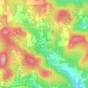
Name: Dunbar topographic map, elevation, terrain.

Location: Dunbar, Town of Windsor, Broome County, New York, United States (42.09008 -75.74102 42.13008 -75.70102)

Average elevation: 1,588 ft

Minimum elevation: 1,214 ft

Maximum elevation: 1,939 ft

Other topographic maps

Click on a map to view its topography, its elevation and its terrain.

City of Binghamton

United States > New York > Broome County

Binghamton, like all of the Southern Tier of New York, lies on the Allegheny Plateau; hence its hilly terrain. As such, elevations can vary in the city--Downtown, for example, is at an elevation of around 860 feet, while residential homes in the hills can go up to over 1,800 feet, such as on Ingram Hill. The…

Average elevation: 1,053 ft

Town of Chenango

United States > New York > Broome County

Average elevation: 1,178 ft

Town of Vestal

United States > New York > Broome County

Average elevation: 1,220 ft

Town of Kirkwood

United States > New York > Broome County

Average elevation: 1,316 ft

Town of Maine

United States > New York > Broome County

Average elevation: 1,280 ft

Town of Fenton

United States > New York > Broome County

Average elevation: 1,234 ft

City of Binghamton

United States > New York > Broome County

Binghamton, like all of the Southern Tier of New York, lies on the Allegheny Plateau; hence its hilly terrain. As such, elevations can vary in the city--Downtown, for example, is at an elevation of around 860 feet (262 meters), while residential homes in the hills can go up to over 1,800 feet (548 meters),…

Average elevation: 1,053 ft

Village of Deposit

United States > New York > Broome County

Average elevation: 1,168 ft

Town of Colesville

United States > New York > Broome County

Average elevation: 1,355 ft

Endwell

United States > New York > Broome County > Endwell

Average elevation: 978 ft

Town of Sanford

United States > New York > Broome County

Average elevation: 1,516 ft

Town of Fenton

United States > New York > Broome County

Average elevation: 1,234 ft

Town of Binghamton

United States > New York > Broome County

Average elevation: 1,368 ft

Town of Nanticoke

United States > New York > Broome County

Average elevation: 1,299 ft

City of Binghamton

United States > New York > Broome County

Binghamton, like all of the Southern Tier of New York, lies on the Allegheny Plateau; hence its hilly terrain. As such, elevations can vary in the city--Downtown, for example, is at an elevation of around 860 feet, while residential homes in the hills can go up to over 1,800 feet, such as on Ingram Hill. The…

Average elevation: 1,053 ft

Village of Deposit

United States > New York > Broome County

Average elevation: 1,168 ft

Chenango Bridge

United States > New York > Broome County > Chenango Bridge

Chenango Bridge is located at 42°10′00″N 075°51′45″W / 42.16667°N 75.86250°W / 42.16667; -75.86250 (42.1667426, -75.8624167) and its elevation is 896 feet (273 m).

Average elevation: 1,017 ft

Village of Windsor

United States > New York > Broome County

Average elevation: 1,096 ft

Town of Maine

United States > New York > Broome County

Average elevation: 1,280 ft

Town of Vestal

United States > New York > Broome County

Average elevation: 1,220 ft

Town of Vestal

United States > New York > Broome County

Average elevation: 1,220 ft

Oquaga Lake

United States > New York > Broome County > Town of Sanford

Average elevation: 1,690 ft

Gear up for your next adventure:

📚Navigation Handbooks - Master the art of reading topographic maps and using a compass
🎁Geography Themed Gifts - Unique gift ideas for map lovers and geography enthusiasts
🪶Fire Starter Kit - Reliable fire starter for survival and camping
🌧️Backpack Rain Cover - Keep gear dry in wet weather
📡GPS Antenna Upgrade - Enhance GPS reception in remote terrain

As an Amazon Associate, this site earns from qualifying purchases at no extra cost to you.