
Province of Carhuaz topographic map
Interactive map
Click on the map to display elevation.
About this map
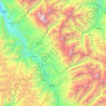
Name: Province of Carhuaz topographic map, elevation, terrain.
Location: Province of Carhuaz, Ancash, Peru (-9.45280 -77.77670 -9.08191 -77.31813)
Average elevation: 13,248 ft
Minimum elevation: 7,375 ft
Maximum elevation: 22,067 ft
The Cordillera Blanca traverses the province. Waskaran, its highest elevation, lies on the border to the Yungay Province. Pallqarahu, Pukaranra, Qupa, Tuqllarahu, Wallqan and Yanarahu belong to the highest peaks of the province. Other mountains are listed below:[2]
Other topographic maps
Click on a map to view its topography, its elevation and its terrain.
Vallunareju Norte
Vallunareju Norte, Tarica, Province of Huaraz, Ancash, Peru
Average elevation: 16,985 ft
San Juan Mountain
San Juan Mountain, Avenida Circunvalacion Nte, Caraz, Province of Huaylas, Ancash, 02165, Peru
Average elevation: 7,999 ft
Collahuasi
Collahuasi, Recuay, Province of Recuay, Ancash, Peru
Average elevation: 11,886 ft
Tortugas
Peru > Ancash > Comandante Noel
Tortugas, Comandante Noel, Province of Casma, Ancash, Peru
Average elevation: 230 ft
Cajamarquilla
Cajamarquilla, Province of Ocros, Ancash, Peru
Average elevation: 11,404 ft
Laguna Radian
Peru > Ancash > Independencia
Laguna Radian, Independencia, Province of Huaraz, Ancash, Peru
Average elevation: 12,838 ft
Carhuayoc
Peru > Ancash > San Marcos
Carhuayoc, San Marcos, Province of Huari, Ancash, Peru
Average elevation: 11,542 ft
Nuevo Chimbote
Peru > Ancash > Nuevo Chimbote
Nuevo Chimbote, Province of Santa, Ancash, Peru
Average elevation: 318 ft
Chavin Archaeological Site
Peru > Ancash > Chavín de Huantar > Chavin de Huantar > Cochas
Chavin Archaeological Site, Cochas, Chavin de Huantar, Chavín de Huantar, Province of Huari, Ancash, Peru
Average elevation: 11,178 ft
Pueblo Libre
Pueblo Libre, Province of Huaylas, Ancash, Peru
Average elevation: 11,572 ft
Nuevo Chimbote
Peru > Ancash > Nuevo Chimbote
Nuevo Chimbote, Santa, Ancash, 02710, Peru
Average elevation: 112 ft
Callo
Peru > Ancash > San Pedro de Chaná > Santa Rita > Callo
Callo, Santa Rita, San Pedro de Chaná, Province of Huari, Ancash, Peru
Average elevation: 11,322 ft
Laguna Purhuay
Laguna Purhuay, Huari, Province of Huari, Ancash, Peru
Average elevation: 12,392 ft
Tocllaraju
Tocllaraju, Tarica, Huaraz, Ancash, Peru
Average elevation: 17,451 ft
Laguna Palococha
Laguna Palococha, AN-110, Ticapampa, Province of Recuay, Ancash, Peru
Average elevation: 12,352 ft
Province of Recuay
Province of Recuay, Cátac, Recuay, Ancash, Peru
Average elevation: 13,885 ft
Province of Carhuaz
Province of Carhuaz, Marcará, Carhuaz, Ancash, Peru
Average elevation: 10,554 ft
Alpamayo
Peru > Ancash > Santa Cruz
Alpamayo, Santa Cruz, Huaylas, Ancash, Peru
Average elevation: 17,093 ft
Laguna Palococha
Laguna Palococha, AN-110, Ticapampa, Recuay, Ancash, Peru
Average elevation: 12,352 ft