
西安街道 topographic map
Interactive map
Click on the map to display elevation.
About this map
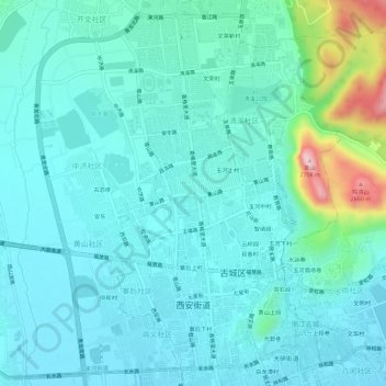
Name: 西安街道 topographic map, elevation, terrain.
Location: 西安街道, 古城区, 丽江市, 云南省, 中国 (26.86794 100.20740 26.91413 100.26453)
Average elevation: 7,986 ft
Minimum elevation: 7,818 ft
Maximum elevation: 8,832 ft
西安街道是中国云南省丽江市古城区下辖的一个街道,位于大研街道(丽江古城)以西,南面是祥和街道,西北方是束河街道以及玉龙县白沙镇。西安街道是古城区人民政府的所在地。面积20平方千米,人口50,953人,以纳西族为主。平均海拔2,400米。
Other topographic maps
Click on a map to view its topography, its elevation and its terrain.