
Make a donation
Gear up for your next adventure:
As an Amazon Associate, this site earns from qualifying purchases at no extra cost to you.
Comox topographic map
Click on the map to display elevation.
Make a donation
Gear up for your next adventure:
As an Amazon Associate, this site earns from qualifying purchases at no extra cost to you.
About this map
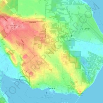
Name: Comox topographic map, elevation, terrain.
Average elevation: 112 ft
Minimum elevation: -3 ft
Maximum elevation: 335 ft
Make a donation
Gear up for your next adventure:
As an Amazon Associate, this site earns from qualifying purchases at no extra cost to you.
Other topographic maps
Click on a map to view its topography, its elevation and its terrain.
Fanny Bay
Canada > British Columbia > Comox Valley Regional District > Area A (Baynes Sound)
Average elevation: 118 ft
Dove Creek
Canada > British Columbia > Comox Valley Regional District > Area C (Puntledge/Black Creek)
Average elevation: 138 ft
Forbidden Plateau
Canada > British Columbia > Comox Valley Regional District > Area C (Puntledge/Black Creek)
Average elevation: 3,415 ft
Mount Washington
Canada > British Columbia > Comox Valley Regional District > Area C (Puntledge/Black Creek)
Average elevation: 4,196 ft
Make a donation
Gear up for your next adventure:
As an Amazon Associate, this site earns from qualifying purchases at no extra cost to you.
Black Creek
Canada > British Columbia > Comox Valley Regional District > Area C (Puntledge/Black Creek)
Average elevation: 197 ft
Royston
Canada > British Columbia > Comox Valley Regional District > Area A (Baynes Sound)
Average elevation: 95 ft
Courtenay
Canada > British Columbia > Comox Valley Regional District > Courtenay
Average elevation: 614 ft
Union Bay
Canada > British Columbia > Comox Valley Regional District > Area A (Baynes Sound)
Average elevation: 128 ft
Make a donation
Gear up for your next adventure:
As an Amazon Associate, this site earns from qualifying purchases at no extra cost to you.
Croteau Lake
Canada > British Columbia > Comox Valley Regional District > Area C (Puntledge/Black Creek)
Average elevation: 3,921 ft
Buckley Bay
Canada > British Columbia > Comox Valley Regional District > Area A (Baynes Sound)
Average elevation: 115 ft
Nymph Falls
Canada > British Columbia > Comox Valley Regional District > Area C (Puntledge/Black Creek)
Average elevation: 420 ft
Mount Albert Edward
Canada > British Columbia > Comox Valley Regional District > Area C (Puntledge/Black Creek)
Average elevation: 4,948 ft
Make a donation
Gear up for your next adventure:
As an Amazon Associate, this site earns from qualifying purchases at no extra cost to you.
Mount Becher
Canada > British Columbia > Comox Valley Regional District > Area C (Puntledge/Black Creek)
Average elevation: 3,396 ft
Waveland
Canada > British Columbia > Comox Valley Regional District > Area B (Lazo North)
Average elevation: 125 ft
Little River
Canada > British Columbia > Comox Valley Regional District > Area B (Lazo North)
Average elevation: 43 ft
MacAulay Heights
Canada > British Columbia > Comox Valley Regional District > Area C (Puntledge/Black Creek)
Average elevation: 308 ft
Make a donation
Gear up for your next adventure:
As an Amazon Associate, this site earns from qualifying purchases at no extra cost to you.
Miracle Beach
Canada > British Columbia > Comox Valley Regional District > Area C (Puntledge/Black Creek) > Miracle Beach
Average elevation: 98 ft
Oyster River
Canada > British Columbia > Comox Valley Regional District > Area C (Puntledge/Black Creek)
Average elevation: 3,192 ft
Beaufort Range
Canada > British Columbia > Comox Valley Regional District > Area A (Baynes Sound)
Average elevation: 1,427 ft
Mount Curran
Canada > British Columbia > Comox Valley Regional District > Area A (Baynes Sound)
Average elevation: 3,747 ft
Make a donation
Gear up for your next adventure:
As an Amazon Associate, this site earns from qualifying purchases at no extra cost to you.
Forbidden Plateau
Canada > British Columbia > Comox Valley Regional District > Area C (Puntledge/Black Creek)
Average elevation: 2,133 ft