Geolocate

Avoca topographic map

Click on the map to display elevation.

About this map

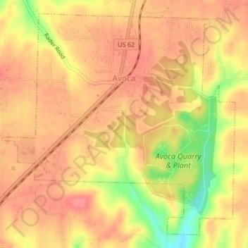
Name: Avoca topographic map, elevation, terrain.

Location: Avoca, Benton County, Arkansas, 72756, United States (36.38452 -94.08847 36.40862 -94.05699)

Average elevation: 1,319 ft

Minimum elevation: 1,152 ft

Maximum elevation: 1,391 ft

Benton County trails, hiking, mountain biking, running and outdoor activities

Other topographic maps

Click on a map to view its topography, its elevation and its terrain.

Loch Lomond

United States > Arkansas > Benton County > Bella Vista

Average elevation: 1,181 ft

Hiwasse

United States > Arkansas > Benton County > Gravette

Average elevation: 1,293 ft

Maysville

United States > Arkansas > Benton County

Average elevation: 1,060 ft

Prairie Creek

United States > Arkansas > Benton County > Rogers

Average elevation: 1,276 ft

Dug Hill

United States > Arkansas > Benton County > Bella Vista

Average elevation: 1,129 ft

Lake Windsor

United States > Arkansas > Benton County > Bella Vista

Average elevation: 1,155 ft

Rago

United States > Arkansas > Benton County > Bella Vista

Average elevation: 1,240 ft

Lake Avalon

United States > Arkansas > Benton County > Bella Vista

Average elevation: 1,158 ft

Lost Bridge Village

United States > Arkansas > Benton County

Average elevation: 1,237 ft

Garfield

United States > Arkansas > Benton County > Garfield

Average elevation: 1,486 ft

Lake Springdale

United States > Arkansas > Benton County > Springdale

Average elevation: 1,286 ft

Oak Grove

United States > Arkansas > Benton County > Oak Grove

Average elevation: 1,188 ft

Healing Springs

United States > Arkansas > Benton County

Average elevation: 1,198 ft

Silent Grove

United States > Arkansas > Benton County > Springdale

Average elevation: 1,293 ft

Pedro

United States > Arkansas > Benton County

Average elevation: 1,096 ft

Gear up for your next adventure:

🧤Hiking Gloves - Protective gloves for rugged trails
🔭Compact Binoculars - HD vision for scouting terrain and identifying distant landmarks
🏫Relief Map Kits - Hands-on tools for teaching landforms and elevation
🛠️Outdoor Gear Repair Kit - Essential tools to fix gear on the trail
🕶️Glacier Sunglasses - Side shields to protect eyes from high-altitude snow glare

As an Amazon Associate, this site earns from qualifying purchases at no extra cost to you.