
Eaton topographic map
Click on the map to display elevation.
About this map
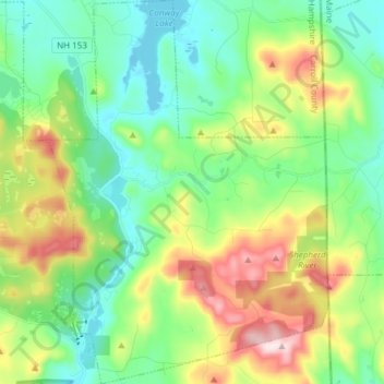
Name: Eaton topographic map, elevation, terrain.
Location: Eaton, Carroll County, New Hampshire, 03832, United States (43.85537 -71.10195 43.96408 -70.99175)
Average elevation: 860 ft
Minimum elevation: 430 ft
Maximum elevation: 1,788 ft
Carroll County trails, hiking, mountain biking, running and outdoor activities
Other topographic maps
Click on a map to view its topography, its elevation and its terrain.
Everrett Field
United States > New Hampshire > Carroll County > Sandwich > Center Sandwich
Average elevation: 719 ft
Mirror Lake
United States > New Hampshire > Carroll County > Tuftonboro > Mirror Lake
Average elevation: 554 ft
Mount Willard
United States > New Hampshire > Carroll County > Hart's Location
Average elevation: 2,543 ft
Bill Rae Conservation Area
United States > New Hampshire > Carroll County > Wolfeboro > Stockbridge Corner
Average elevation: 801 ft
Mount Washington Valley
United States > New Hampshire > Carroll County > Conway > North Conway
Average elevation: 820 ft
Sawyers River
United States > New Hampshire > Carroll County > Hart's Location
Average elevation: 1,499 ft
Big Attitash Mountain
United States > New Hampshire > Carroll County > Bartlett
Average elevation: 2,333 ft
Brookfield
United States > New Hampshire > Carroll County > Brookfield
According to the United States Census Bureau, the town has a total area of 23.2 square miles (60.2 km2), of which 22.8 sq mi (59.1 km2) are land and 0.42 sq mi (1.1 km2) are water, comprising 1.82% of the town.[1] Brookfield is drained primarily by the Branch River and Pike Brook, within the Piscataqua River…
Average elevation: 640 ft