Geolocate

Jumbo topographic map

Click on the map to display elevation.

About this map

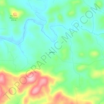
Name: Jumbo topographic map, elevation, terrain.

Location: Jumbo, Izard County, Arkansas, United States (36.04007 -91.99959 36.08007 -91.95959)

Average elevation: 604 ft

Minimum elevation: 404 ft

Maximum elevation: 1,030 ft

Izard County trails, hiking, mountain biking, running and outdoor activities

Other topographic maps

Click on a map to view its topography, its elevation and its terrain.

Mount Pleasant

United States > Arkansas > Izard County

Average elevation: 673 ft

Franklin

United States > Arkansas > Izard County

Average elevation: 666 ft

Guion

United States > Arkansas > Izard County

Average elevation: 466 ft

Pineville

United States > Arkansas > Izard County

Average elevation: 653 ft

Melbourne

United States > Arkansas > Izard County

Average elevation: 659 ft

Gear up for your next adventure:

🔌Solar Panel Charger - Charge gear sustainably outdoors
🩹Survival Bandages - High‑quality bandages for emergencies
🏥Hiking First Aid Kits - Comprehensive medical kits for remote trail injuries
🛶Inflatable Kayak - Portable kayak for rivers, lakes, and expeditions
🔭Telescopic Hiking Pole - Adjustable pole for hiking stability

As an Amazon Associate, this site earns from qualifying purchases at no extra cost to you.