Geolocate

Mount Pleasant topographic map

Click on the map to display elevation.

About this map

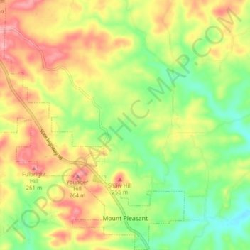
Name: Mount Pleasant topographic map, elevation, terrain.

Location: Mount Pleasant, Izard County, Arkansas, 72561, United States (35.95386 -91.80618 36.01604 -91.73734)

Average elevation: 673 ft

Minimum elevation: 492 ft

Maximum elevation: 869 ft

Izard County trails, hiking, mountain biking, running and outdoor activities

Other topographic maps

Click on a map to view its topography, its elevation and its terrain.

Sage

United States > Arkansas > Izard County

Average elevation: 735 ft

Mount Olive

United States > Arkansas > Izard County

Average elevation: 479 ft

Violet Hill

United States > Arkansas > Izard County

Average elevation: 761 ft

Dolph

United States > Arkansas > Izard County

Average elevation: 823 ft

Forty Four

United States > Arkansas > Izard County

Average elevation: 581 ft

Gid

United States > Arkansas > Izard County

Average elevation: 643 ft

Jumbo

United States > Arkansas > Izard County

Average elevation: 604 ft

Lunenburg

United States > Arkansas > Izard County

Average elevation: 525 ft

Sylamore

United States > Arkansas > Izard County

Average elevation: 531 ft

Wideman

United States > Arkansas > Izard County

Average elevation: 627 ft

Wiseman

United States > Arkansas > Izard County

Average elevation: 650 ft

Zion

United States > Arkansas > Izard County

Average elevation: 650 ft

Gear up for your next adventure:

🪶Trail Camera - Capture wildlife on your hikes
🥘Titanium Cookware - Durable, featherlight pots and pans for backpacking
🌎3D Topographic Globes - Raised relief globes for a tactile understanding of geography
🎒Trekking Poles - Sturdy poles for balance and stability on rough terrain
🔥Camping Stove - Portable stove for camping and backcountry cooking

As an Amazon Associate, this site earns from qualifying purchases at no extra cost to you.