
Make a donation
Gear up for your next adventure:
As an Amazon Associate, this site earns from qualifying purchases at no extra cost to you.
Głogów County topographic map
Click on the map to display elevation.
Make a donation
Gear up for your next adventure:
As an Amazon Associate, this site earns from qualifying purchases at no extra cost to you.
About this map
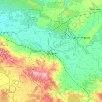
Name: Głogów County topographic map, elevation, terrain.
Location: Głogów County, Lower Silesian Voivodeship, Poland (51.53781 15.83426 51.80475 16.35545)
Average elevation: 341 ft
Minimum elevation: 210 ft
Maximum elevation: 745 ft
Make a donation
Gear up for your next adventure:
As an Amazon Associate, this site earns from qualifying purchases at no extra cost to you.
Other topographic maps
Click on a map to view its topography, its elevation and its terrain.
Śnieżka / Sněžka
Poland > Lower Silesian Voivodeship > Karkonosze County > Karpacz
Due to high altitude the climate is maritime polar (Köppen: ET) not far from a continental subpolar climate (Dfc). The difference should be at least 6 °C lower on annual average compared to the weather station in the plains.
Average elevation: 4,144 ft
Sudety
Poland > Lower Silesian Voivodeship > Ząbkowice Śląskie County > Starczówek
Average elevation: 961 ft
Make a donation
Gear up for your next adventure:
As an Amazon Associate, this site earns from qualifying purchases at no extra cost to you.
Szary Kamień
Poland > Lower Silesian Voivodeship > Kłodzko County > Lądek-Zdrój
Average elevation: 1,614 ft
Polanica
Poland > Lower Silesian Voivodeship > Ząbkowice Śląskie County > Nowina
Average elevation: 810 ft
Make a donation
Gear up for your next adventure:
As an Amazon Associate, this site earns from qualifying purchases at no extra cost to you.
Jelenia Góra
Poland > Lower Silesian Voivodeship > Jelenia Góra > Jelenia Góra
Average elevation: 1,690 ft
Make a donation
Gear up for your next adventure:
As an Amazon Associate, this site earns from qualifying purchases at no extra cost to you.
Pop
Poland > Lower Silesian Voivodeship > Zgorzelec County > Studniska Dolne
Average elevation: 712 ft
Sienna
Poland > Lower Silesian Voivodeship > Trzebnica County > Rościsławice
Average elevation: 528 ft
Szklana Góra
Poland > Lower Silesian Voivodeship > Zgorzelec County > Stary Węgliniec
Average elevation: 702 ft
Wieżyca
Poland > Lower Silesian Voivodeship > Świdnica County > Dobromierz
Average elevation: 1,073 ft
Make a donation
Gear up for your next adventure:
As an Amazon Associate, this site earns from qualifying purchases at no extra cost to you.