
Make a donation
Gear up for your next adventure:
As an Amazon Associate, this site earns from qualifying purchases at no extra cost to you.
Trzy Korony topographic map
Click on the map to display elevation.
Make a donation
Gear up for your next adventure:
As an Amazon Associate, this site earns from qualifying purchases at no extra cost to you.
About this map
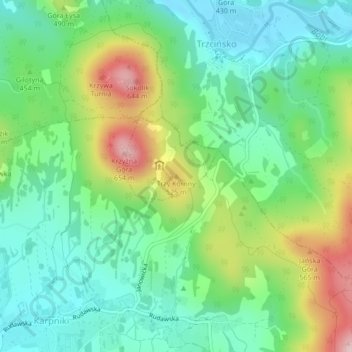
Name: Trzy Korony topographic map, elevation, terrain.
Average elevation: 1,467 ft
Minimum elevation: 1,191 ft
Maximum elevation: 2,034 ft
Make a donation
Gear up for your next adventure:
As an Amazon Associate, this site earns from qualifying purchases at no extra cost to you.
Other topographic maps
Click on a map to view its topography, its elevation and its terrain.
Make a donation
Gear up for your next adventure:
As an Amazon Associate, this site earns from qualifying purchases at no extra cost to you.
Złotoryja
Poland > Lower Silesian Voivodeship > Złotoryja County > Złotoryja
Average elevation: 768 ft
Make a donation
Gear up for your next adventure:
As an Amazon Associate, this site earns from qualifying purchases at no extra cost to you.
Make a donation
Gear up for your next adventure:
As an Amazon Associate, this site earns from qualifying purchases at no extra cost to you.
Make a donation
Gear up for your next adventure:
As an Amazon Associate, this site earns from qualifying purchases at no extra cost to you.
Make a donation
Gear up for your next adventure:
As an Amazon Associate, this site earns from qualifying purchases at no extra cost to you.
Kamień
Poland > Lower Silesian Voivodeship > Lwówek Śląski County > Kamień
Average elevation: 1,273 ft
Szklarska Poręba
Poland > Lower Silesian Voivodeship > Karkonosze County > Szklarska Poręba
Average elevation: 2,923 ft
Bolesławiec
Poland > Lower Silesian Voivodeship > Bolesławiec County > Bolesławiec
Average elevation: 659 ft
Make a donation
Gear up for your next adventure:
As an Amazon Associate, this site earns from qualifying purchases at no extra cost to you.