
Tebay topographic map
Click on the map to display elevation.
About this map
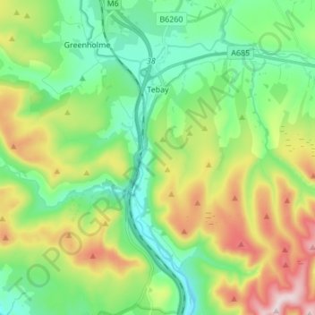
Name: Tebay topographic map, elevation, terrain.
Location: Tebay, Westmorland and Furness, England, United Kingdom (54.38672 -2.68013 54.44608 -2.54393)
Average elevation: 981 ft
Minimum elevation: 433 ft
Maximum elevation: 2,103 ft
Other topographic maps
Click on a map to view its topography, its elevation and its terrain.
Helvellyn
United Kingdom > England > Westmorland and Furness > Patterdale
Red Tarn, a classic corrie tarn, is a high-elevation tarn with low nutrient levels and poor in the number of species it supports. Characteristic vegetation zones include a water-starwort (Callitriche) in shallower areas and the alga Nitella flexilis in deeper water and around the inlet. Other species include a…
Average elevation: 2,231 ft
Alston
United Kingdom > England > Westmorland and Furness
Alston is a town in Cumbria, England, within the civil parish of Alston Moor on the River South Tyne. It shares the title of the 'highest market town in England', at about 1,000 feet (300 m) above sea level, with Buxton, Derbyshire. Despite its altitude, the town is easily accessible via the many roads which…
Average elevation: 1,325 ft
Wansfell Pike
United Kingdom > England > Westmorland and Furness > Ambleside
Wansfell has an extensive summit ridge with two tops. The highest point of the fell is called Baystones with a height of 488 m (1,601 ft), while Wansfell Pike, which lies a kilometre to the south west reaches an elevation of 482 m (1,581 ft). Of the two summits, Wansfell Pike is regarded as the “true”…
Average elevation: 935 ft
Mallerstang Edge
United Kingdom > England > Westmorland and Furness > Mallerstang
Average elevation: 1,604 ft
High Dale Park
United Kingdom > England > Westmorland and Furness > Satterthwaite
Average elevation: 459 ft
Hartsop Above How
United Kingdom > England > Westmorland and Furness > Patterdale
Average elevation: 1,407 ft
Howgill Fells
United Kingdom > England > Westmorland and Furness > Ravenstonedale
Average elevation: 994 ft
Lindeth
United Kingdom > England > Westmorland and Furness > Bowness-on-Windermere
Average elevation: 364 ft
Old Man of Coniston
United Kingdom > England > Westmorland and Furness > Coniston
The first section rising steeply from Coniston is a metalled road, maintained partly to provide access to the quarry. This leads to a car park at an altitude of 740 ft (230 m), a popular starting point for climbs. Beyond here motor vehicles are prohibited, but the track continues to its summit at 2,000 ft (610…
Average elevation: 1,644 ft
Wharton Tarn
United Kingdom > England > Westmorland and Furness > Hawkshead > Hawkshead Hill
Average elevation: 568 ft
Stony Cove Pike
United Kingdom > England > Westmorland and Furness > Patterdale
Stony Cove Pike (alternatively known as Caudale Moor /kʊərdeɪl mʊər/ or John Bell's Banner) is a fell in the Far Eastern part of the English Lake District. It stands on the other side of the Kirkstone Pass from Red Screes, and is on the end of a ridge coming down from High Street. It is separated from its…
Average elevation: 1,775 ft
Levers Water
United Kingdom > England > Westmorland and Furness > Coniston
Average elevation: 1,696 ft
Undermillbeck Common
United Kingdom > England > Westmorland and Furness > Crook
Average elevation: 472 ft
Sheffield Pike
United Kingdom > England > Westmorland and Furness > Patterdale
Average elevation: 1,529 ft
Hawkshead Hill
United Kingdom > England > Westmorland and Furness > Hawkshead
Average elevation: 515 ft
Wood Broughton
United Kingdom > England > Westmorland and Furness > Field Broughton
Average elevation: 322 ft
Black Fell
United Kingdom > England > Westmorland and Furness > Hawkshead
Black Fell is the high point in the hilly area bounded by Windermere, Langdale and Coniston. It occupies an area of around one mile by two, clad mainly in fell grass with many small outcrops of rock. Despite its modest altitude Alfred Wainwright accorded Black Fell a chapter in his Pictorial Guide to the…
Average elevation: 558 ft
Red Screes
United Kingdom > England > Westmorland and Furness > Patterdale
Average elevation: 1,683 ft
Rampsgill Head (summit)
United Kingdom > England > Westmorland and Furness
Average elevation: 1,900 ft
Hartsop Dodd
United Kingdom > England > Westmorland and Furness > Patterdale
Average elevation: 1,188 ft
St Sunday Crag
United Kingdom > England > Westmorland and Furness > Patterdale
Average elevation: 1,604 ft
Friars Ground
United Kingdom > England > Westmorland and Furness > Beck Side
Average elevation: 456 ft
Cross Fell
United Kingdom > England > Westmorland and Furness
Cross Fell, Great Dun Fell and Little Dun Fell form a block of high terrain which is all over 800 metres (2,625 ft) in elevation. This is the largest block of high ground in England and tends to retain snow-cover longer than neighbouring areas. Snow can be found in gullies on the north side of Cross Fell as…
Average elevation: 2,470 ft
Place Fell
United Kingdom > England > Westmorland and Furness > Patterdale
Place Fell can be climbed from Patterdale, either via Boredale Hause or more directly by aiming up the face between Bleaberry Knott and The Knight. Ascents can also be made from Sandwick up either of the north eastern ridges, or from Boredale via the Hause. The altitude gain from the shores of Ullswater to the…
Average elevation: 1,119 ft
Pennines
United Kingdom > England > Westmorland and Furness
The Pennine climate is generally temperate like that of the rest of England, but the hills have more precipitation, stronger winds and colder weather than the surrounding areas. Higher elevations have a tundra climate. More snow falls on the Pennines than on surrounding lowland areas due to the elevation and…
Average elevation: 2,497 ft
Deepdale Beck
United Kingdom > England > Westmorland and Furness > South Lakeland > Dent
Average elevation: 919 ft
Black Force
United Kingdom > England > Westmorland and Furness > South Lakeland
Average elevation: 1,434 ft
Scout Scar
United Kingdom > England > Westmorland and Furness > Brigsteer
Scout Scar, also called Underbarrow Scar, is a hill in the English Lake District, west of Kendal, Cumbria and above the village of Underbarrow. It reaches 771 feet (235 m). Scout Scar is the subject of a chapter of Wainwright's book The Outlying Fells of Lakeland, but the summit he describes is a lower summit…
Average elevation: 427 ft
Great How
United Kingdom > England > Westmorland and Furness > Little Langdale > Stang End
Average elevation: 518 ft