
Make a donation
Gear up for your next adventure:
As an Amazon Associate, this site earns from qualifying purchases at no extra cost to you.
Kesseling topographic map
Click on the map to display elevation.
Make a donation
Gear up for your next adventure:
As an Amazon Associate, this site earns from qualifying purchases at no extra cost to you.
About this map
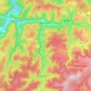
Name: Kesseling topographic map, elevation, terrain.
Average elevation: 1,404 ft
Minimum elevation: 564 ft
Maximum elevation: 2,215 ft
Make a donation
Gear up for your next adventure:
As an Amazon Associate, this site earns from qualifying purchases at no extra cost to you.
Other topographic maps
Click on a map to view its topography, its elevation and its terrain.
Eifel
Deutschland > Rheinland-Pfalz > Landkreis Ahrweiler > Adenau
Im Handbuch der naturräumlichen Gliederung Deutschlands wurde in den Jahren bis 1960 der deutsche Teil der zum Rheinischen Schiefergebirge gehörenden Eifel naturräumlich in drei Haupteinheitengruppen (zweistellig) und diese weiter in Haupteinheiten (dreistellig) unterteilt. Diese Gliederungen wurden…
Average elevation: 1,919 ft
Rodderberg
Deutschland > Rheinland-Pfalz > Landkreis Ahrweiler > Remagen > Rolandswerth
Der Rodderberg liegt direkt oberhalb vom nördlichen Ausgang des Mittelrheintals. Zusammen mit dem fast direkt gegenüberliegenden Drachenfels verengt er das Rheintal. Diese Engstelle bildet die Südgrenze der Kölner Bucht, während sich südlich dieser Engstelle die kleine Talverbreiterung von Oberwinter…
Average elevation: 348 ft
Laacher See
Deutschland > Rheinland-Pfalz > Landkreis Ahrweiler > Glees
Das geförderte vulkanische Material war vorwiegend von phonolithischem Typ, der nur in der dritten Phase einen zunehmend höheren Anteil an primitiverem mafischem Material enthielt. Über die Gesamtmenge des Materials herrscht Uneinigkeit. So ist von 6 km³ DRE entsprechend 16–20 km³ Lockermassen die Rede,…
Average elevation: 1,030 ft
Make a donation
Gear up for your next adventure:
As an Amazon Associate, this site earns from qualifying purchases at no extra cost to you.
Freisheim
Deutschland > Rheinland-Pfalz > Landkreis Ahrweiler > Berg > Freisheim
Average elevation: 1,198 ft
Landskrone
Deutschland > Rheinland-Pfalz > Landkreis Ahrweiler > Bad Neuenahr-Ahrweiler
Ahrschleife bei Altenahr | An der Teufelsley | Aremberg | Bausenberg | Dachsbusch | Hohe Acht | Hürs-Nück | In der Burwies | Laacher See | Landskrone | Lehrenkopf | Meirother Kopf und Tiefenstein | Mündungsgebiet der Ahr | Nürburg | Quiddelbacher Höhe / Nürburgring | Olbrück | Perler Kopf | Quellgebiet…
Average elevation: 423 ft
Oberwinter
Deutschland > Rheinland-Pfalz > Landkreis Ahrweiler > Remagen > Oberwinter
Oberwinter liegt am nördlichen Mittelrhein am linken Ufer gegenüber der Ortsgemeinde Rheinbreitbach. Der Ort lässt sich naturräumlich der Honnefer Talweitung zuordnen, die sich linksrheinisch durch ein bis über 100 m hohes Steilufer kennzeichnet, dem rechtsrheinisch ein wesentlich breiterer, halbmondartig…
Average elevation: 394 ft
Make a donation
Gear up for your next adventure:
As an Amazon Associate, this site earns from qualifying purchases at no extra cost to you.
Franken
Deutschland > Rheinland-Pfalz > Landkreis Ahrweiler > Sinzig
Franken ist der südlichste und der einwohnermäßig kleinste Ortsbezirk von Sinzig im Landkreis Ahrweiler in Rheinland-Pfalz. Er liegt abseits des Stadtbereichs auf den Randhöhen der Eifel im Quellgebiet des Frankenbaches, oberhalb des Wasserschlosses Ahrenthal. Zu Franken gehört der Wohnplatz Marienhof.
Average elevation: 669 ft
Make a donation
Gear up for your next adventure:
As an Amazon Associate, this site earns from qualifying purchases at no extra cost to you.
Abtei Maria Laach
Deutschland > Rheinland-Pfalz > Landkreis Ahrweiler > Glees > Abtei Maria Laach
Average elevation: 1,083 ft
Make a donation
Gear up for your next adventure:
As an Amazon Associate, this site earns from qualifying purchases at no extra cost to you.
Remagen
Deutschland > Rheinland-Pfalz > Landkreis Ahrweiler > Remagen > Remagen
Remagen liegt im Unteren Mittelrheintal gegenüber der rechtsrheinischen Ortsgemeinde Erpel am Nordrand der Goldenen Meile, einer bis nach Bad Breisig reichenden fruchtbaren Talebene, die südlich des Ortsteils Kripp die Ahrmündung aufnimmt. Nach Nordwesten hin verengt sich das Stadtzentrum mit dem Rheintal;…
Average elevation: 456 ft
Krälingen
Deutschland > Rheinland-Pfalz > Landkreis Ahrweiler > Berg > Krälingen
Average elevation: 1,089 ft
Rolandswerth
Deutschland > Rheinland-Pfalz > Landkreis Ahrweiler > Remagen
Rolandswerth erstreckt sich am linken Rheinufer zwischen Mehlem im Nordwesten und Rolandseck im Süden, zu denen entlang der Bundesstraße 9 ein fließender Übergang besteht. Die Ortschaft umfasst Höhenlagen zwischen 54 m ü. NHN und 105 m ü. NHN, wobei sie sich nach Süden deutlich verjüngt.…
Average elevation: 348 ft
Make a donation
Gear up for your next adventure:
As an Amazon Associate, this site earns from qualifying purchases at no extra cost to you.
Hohe Acht
Deutschland > Rheinland-Pfalz > Landkreis Ahrweiler > Herschbroich
Average elevation: 1,824 ft
Vettelhoven
Deutschland > Rheinland-Pfalz > Landkreis Ahrweiler > Grafschaft
Average elevation: 794 ft
Make a donation
Gear up for your next adventure:
As an Amazon Associate, this site earns from qualifying purchases at no extra cost to you.
Ruine Wensburg
Deutschland > Rheinland-Pfalz > Landkreis Ahrweiler > Obliers
Direkt neben den Wohnturm befand sich südlich davon früher der einstige Zugang zum Kernburgbereich. Seine profilierten Steine aus Trachyt finden sich heute verstreut auf dem Burgareal. Die Hauptburg war noch in den 1930er Jahren von einem sieben Meter hohen Bering umgeben, dessen Höhe heute jedoch kaum mehr…
Average elevation: 1,115 ft
Burg Kreuzberg
Deutschland > Rheinland-Pfalz > Landkreis Ahrweiler > Kreuzberg
Die Burg Kreuzberg steht auf einem kleinen Felskegel oberhalb des Altenahrer Ortsteils Kreuzberg. Die Anlage befindet sich auf einem dreieckigen Felsplateau, das an einer Seite steil zur Ahr abfällt, und gehört damit zum Typus der Höhenburg.
Average elevation: 889 ft
Motte Kasselsburg
Deutschland > Rheinland-Pfalz > Landkreis Ahrweiler > Meuspath
Average elevation: 1,775 ft
Make a donation
Gear up for your next adventure:
As an Amazon Associate, this site earns from qualifying purchases at no extra cost to you.
Burg Aremberg
Deutschland > Rheinland-Pfalz > Landkreis Ahrweiler > Aremberg
Die Burg Aremberg bei Aremberg im rheinland-pfälzischen Landkreis Ahrweiler ist die Ruine einer mittelalterlichen Höhenburg auf dem Aremberg im Ahrgebirge (Eifel).
Average elevation: 1,437 ft
Make a donation
Gear up for your next adventure:
As an Amazon Associate, this site earns from qualifying purchases at no extra cost to you.
Make a donation
Gear up for your next adventure:
As an Amazon Associate, this site earns from qualifying purchases at no extra cost to you.
Bölingen
Deutschland > Rheinland-Pfalz > Landkreis Ahrweiler > Grafschaft > Bölingen
Average elevation: 741 ft
Make a donation
Gear up for your next adventure:
As an Amazon Associate, this site earns from qualifying purchases at no extra cost to you.
Dungkopfsee
Deutschland > Rheinland-Pfalz > Landkreis Ahrweiler > Remagen > Unkelbach
Average elevation: 581 ft
Binzenbach
Deutschland > Rheinland-Pfalz > Landkreis Ahrweiler
Der Ortsteil liegt in der Eifel, umgeben von bewaldeten Höhen, im tief eingeschnittenen oberen Sahrbachtal. In den Sahrbach, einem linken Nebenfluss der Ahr, münden vor Ort der Binzenbach und der Effelsberger Bach.
Average elevation: 1,220 ft
Make a donation
Gear up for your next adventure:
As an Amazon Associate, this site earns from qualifying purchases at no extra cost to you.
Reimerzhoven
Deutschland > Rheinland-Pfalz > Landkreis Ahrweiler > Altenburg > Reimerzhoven
Average elevation: 906 ft
Berg
Deutschland > Rheinland-Pfalz > Landkreis Ahrweiler > Berg > Berg
Ortsteile sind Berg, Freisheim, Krälingen, Häselingen, Vellen und Vischel. Zur Gemeinde gehören auch die Wohnplätze Forsthaus Vilma Höhe und Weißerath.
Average elevation: 1,178 ft
Neuenahrer Berg
Deutschland > Rheinland-Pfalz > Landkreis Ahrweiler > Bad Neuenahr-Ahrweiler
Average elevation: 699 ft
Make a donation
Gear up for your next adventure:
As an Amazon Associate, this site earns from qualifying purchases at no extra cost to you.
Eifel
Deutschland > Rheinland-Pfalz > Landkreis Ahrweiler > Adenau
Im Handbuch der naturräumlichen Gliederung Deutschlands wurde in den Jahren bis 1960 der deutsche Teil der zum Rheinischen Schiefergebirge gehörenden Eifel naturräumlich in drei Haupteinheitengruppen (zweistellig) und diese weiter in Haupteinheiten (dreistellig) unterteilt. Diese Gliederungen wurden…
Average elevation: 1,919 ft