Geolocate

Aurano topographic map

Click on the map to display elevation.

About this map

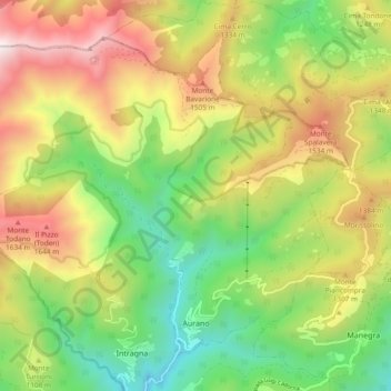
Name: Aurano topographic map, elevation, terrain.

Location: Aurano, Verbano-Cusio-Ossola, Piedmont, 28812, Italy (45.99413 8.53203 46.04670 8.62604)

Average elevation: 3,491 ft

Minimum elevation: 1,342 ft

Maximum elevation: 6,352 ft

Other topographic maps

Click on a map to view its topography, its elevation and its terrain.

Oira

Italy > Piedmont > Verbano-Cusio-Ossola > Crevoladossola

Average elevation: 2,385 ft

Mottarone

Italy > Piedmont > Verbano-Cusio-Ossola > Stresa

Mottarone is a mountain in the Western Alps of Piedmont, north-western Italy, with an elevation of 1,492 metres (4,895 ft). It is located between the provinces of Verbano-Cusio-Ossola and Novara.

Average elevation: 3,862 ft

Zoverallo

Italy > Piedmont > Verbano-Cusio-Ossola > Verbania

Average elevation: 1,056 ft

Cireggio

Italy > Piedmont > Verbano-Cusio-Ossola > Omegna

Average elevation: 1,686 ft

Solivo

Italy > Piedmont > Verbano-Cusio-Ossola > Cannobio

Average elevation: 1,257 ft

Riale / Chärbäch

Italy > Piedmont > Verbano-Cusio-Ossola > Formazza

Average elevation: 6,936 ft

Prati

Italy > Piedmont > Verbano-Cusio-Ossola > Macugnaga

Average elevation: 5,935 ft

Cascata

Italy > Piedmont > Verbano-Cusio-Ossola > Formazza

Average elevation: 6,529 ft

Iselle

Italy > Piedmont > Verbano-Cusio-Ossola > Trasquera

Average elevation: 4,419 ft

Carcioni

Italy > Piedmont > Verbano-Cusio-Ossola

Average elevation: 1,109 ft

Castello

Italy > Piedmont > Verbano-Cusio-Ossola > Varzo

Average elevation: 3,209 ft

Prà della Marta

Italy > Piedmont > Verbano-Cusio-Ossola > Brolo

Average elevation: 1,611 ft

Oggiogno

Italy > Piedmont > Verbano-Cusio-Ossola

Average elevation: 1,880 ft

Pianezza

Italy > Piedmont > Verbano-Cusio-Ossola > Bolco

Average elevation: 2,018 ft

Quarazza

Italy > Piedmont > Verbano-Cusio-Ossola > Macugnaga

Average elevation: 5,463 ft

Pianezza

Italy > Piedmont > Verbano-Cusio-Ossola > San Carlo

Average elevation: 3,491 ft

Borca

Italy > Piedmont > Verbano-Cusio-Ossola > Omegna

Average elevation: 1,673 ft

Gear up for your next adventure:

🗺️NatGeo Topo Maps - High-quality waterproof printed topographic maps of US Parks
🖼️Topo Map Wall Art - Decorative topographic prints of famous peaks and regions
🔋Solar Power Banks - Keep your GPS and phone charged in remote wilderness areas
🔥Plasma Lighters - Windproof lighters that work in any weather condition
🎒Gear Packing Cubes - Organize your backpack efficiently

As an Amazon Associate, this site earns from qualifying purchases at no extra cost to you.