Geolocate

De Beque topographic map

Click on the map to display elevation.

About this map

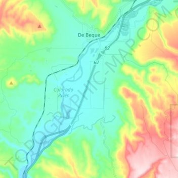
Name: De Beque topographic map, elevation, terrain.

Location: De Beque, Mesa County, Colorado, United States (39.25691 -108.22222 39.35346 -108.16632)

Average elevation: 5,240 ft

Minimum elevation: 4,843 ft

Maximum elevation: 6,198 ft

Mesa County trails, hiking, mountain biking, running and outdoor activities

Other topographic maps

Click on a map to view its topography, its elevation and its terrain.

Whitewater

United States > Colorado > Mesa County

Average elevation: 4,724 ft

Glade Park

United States > Colorado > Mesa County

Average elevation: 6,923 ft

Clifton

United States > Colorado > Mesa County

Average elevation: 4,695 ft

Gear up for your next adventure:

📡GPS Antenna Upgrade - Enhance GPS reception in remote terrain
🥇GPS Hiking Watch - Multi‑sport GPS watch with navigation and trail tracking
🧣Merino Neck Gaiters - Multi-functional headwear for wind and sun protection
🖼️Topo Map Wall Art - Decorative topographic prints of famous peaks and regions
🔥Fast-Boil Camping Stoves - Efficient cooking systems for quick trail meals

As an Amazon Associate, this site earns from qualifying purchases at no extra cost to you.