
Great Sand Dunes National Preserve topographic map
Interactive map
Click on the map to display elevation.
Great Sand Dunes National Preserve
In 1848, John C. Frémont was hired to find a railroad route from St. Louis to California. He crossed the Sangre de Cristos into the San Luis Valley in winter, courting disaster but proving that a winter crossing of this range was possible. He was followed in 1853 by Captain John Gunnison of the Corps of Topographical Engineers. Gunnison's party crossed the dune field on horseback.
About this map
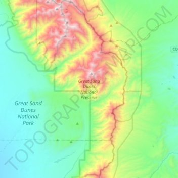
Name: Great Sand Dunes National Preserve topographic map, elevation, terrain.
Average elevation: 9,160 ft
Minimum elevation: 7,572 ft
Maximum elevation: 13,543 ft
Saguache County trails, hiking, mountain biking, running and outdoor activities
Other topographic maps
Click on a map to view its topography, its elevation and its terrain.