Geolocate

Lesser Slave Lake topographic map

Click on the map to display elevation.

About this map

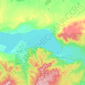
Name: Lesser Slave Lake topographic map, elevation, terrain.

Location: Lesser Slave Lake, Division No. 17, Alberta, Canada (55.29401 -116.10500 55.53400 -114.74600)

Average elevation: 2,313 ft

Minimum elevation: 1,870 ft

Maximum elevation: 3,878 ft

Other topographic maps

Click on a map to view its topography, its elevation and its terrain.

Lac Cardinal

Canada > Alberta > Division No. 17

Average elevation: 2,149 ft

La Crete

Canada > Alberta > Division No. 17

Average elevation: 1,060 ft

Kinuso

Canada > Alberta > Division No. 17

Average elevation: 1,926 ft

Driftpile

Canada > Alberta > Division No. 17

Average elevation: 1,936 ft

Gear up for your next adventure:

🔭Compact Binoculars - HD vision for scouting terrain and identifying distant landmarks
🪑Ultralight Camp Chairs - Portable seating for resting after a long day of mapping
📡Handheld GPS Device - Reliable handheld GPS for outdoor navigation
📌Outdoor GPS Map App - Apps and devices for digital topographic navigation
🚗GPS Dash Cams - Record your scenic drives through mountain passes and canyons

As an Amazon Associate, this site earns from qualifying purchases at no extra cost to you.