
Make a donation
Gear up for your next adventure:
As an Amazon Associate, this site earns from qualifying purchases at no extra cost to you.
Benguela Province topographic map
Click on the map to display elevation.
Make a donation
Gear up for your next adventure:
As an Amazon Associate, this site earns from qualifying purchases at no extra cost to you.
Benguela Province
Benguela Province is situated in the west of the country, on the Atlantic coast. It also borders the provinces of Cuanza Sul (to the north), Namibe (to the southwest), Huila (to the southeast), and Huambo (to the east). It is traversed by the northwesterly line of equal latitude and longitude with three zones: coastal at 0–500 metres (0–1,640 ft); central at 500–1,200 metres (1,600–3,900 ft); and eastern with a medium altitude greater than 1,500 metres (4,900 ft).
Make a donation
Gear up for your next adventure:
As an Amazon Associate, this site earns from qualifying purchases at no extra cost to you.
About this map
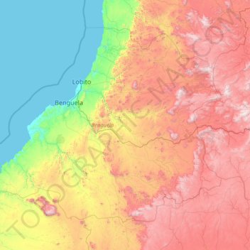
Name: Benguela Province topographic map, elevation, terrain.
Location: Benguela Province, Angola (-13.88838 12.31596 -11.75892 15.11083)
Average elevation: 2,913 ft
Minimum elevation: 0 ft
Maximum elevation: 8,337 ft
Make a donation
Gear up for your next adventure:
As an Amazon Associate, this site earns from qualifying purchases at no extra cost to you.
Other topographic maps
Click on a map to view its topography, its elevation and its terrain.
Saurimo
Saurimo is located in northeastern Angola at an elevation of 1,084 m (3,556 ft) above sea level. It is a garrison town and local market center.
Average elevation: 3,497 ft
Cuito
The town sits on the eastern flank of the Bie Plateau. The climate is unusually cool for its tropical location. The average annual temperature is 18 °C, largely due to its high altitude. The coolest period is May to August when almost no rain falls. September and October are the hottest months with a little…
Average elevation: 5,482 ft
Make a donation
Gear up for your next adventure:
As an Amazon Associate, this site earns from qualifying purchases at no extra cost to you.
Make a donation
Gear up for your next adventure:
As an Amazon Associate, this site earns from qualifying purchases at no extra cost to you.
Make a donation
Gear up for your next adventure:
As an Amazon Associate, this site earns from qualifying purchases at no extra cost to you.