
Wick topographic map
Interactive map
Click on the map to display elevation.
About this map
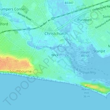
Name: Wick topographic map, elevation, terrain.
Average elevation: 13 ft
Minimum elevation: -13 ft
Maximum elevation: 102 ft
Other topographic maps
Click on a map to view its topography, its elevation and its terrain.
Christchurch
United Kingdom > England > Bournemouth, Christchurch and Poole > Hurn
Christchurch, Hurn, Bournemouth, Christchurch and Poole, England, United Kingdom
Average elevation: 59 ft
Poole
United Kingdom > England > Bournemouth, Christchurch and Poole > Poole
Poole, Bournemouth, Christchurch and Poole, England, United Kingdom
Average elevation: 75 ft
Bournemouth
United Kingdom > England > Bournemouth, Christchurch and Poole > Wick
Bournemouth, Wick, Bournemouth, Christchurch and Poole, England, United Kingdom
Average elevation: 56 ft
East Parley Common
United Kingdom > England > Bournemouth, Christchurch and Poole > Hurn
East Parley Common, Hurn, Bournemouth, Christchurch and Poole, England, United Kingdom
Average elevation: 43 ft
Bournemouth
United Kingdom > England > Bournemouth, Christchurch and Poole
Bournemouth, Bournemouth, Christchurch and Poole, England, BH2 6EG, United Kingdom
Average elevation: 69 ft
Poole
United Kingdom > England > Bournemouth, Christchurch and Poole
Poole, Bournemouth, Christchurch and Poole, England, BH15 1SU, United Kingdom
Average elevation: 52 ft
Hengistbury Head
United Kingdom > England > Bournemouth, Christchurch and Poole
Hengistbury Head, Bournemouth, Christchurch and Poole, England, BH6 4EW, United Kingdom
Average elevation: 0 ft
Merley
United Kingdom > England > Bournemouth, Christchurch and Poole
Merley, Bournemouth, Christchurch and Poole, England, BH21 3AQ, United Kingdom
Average elevation: 112 ft
Holes Bay
United Kingdom > England > Bournemouth, Christchurch and Poole > Poole
Holes Bay, Sterte, Poole, Bournemouth, Christchurch and Poole, South West England, England, BH15 2BD, United Kingdom
Average elevation: 13 ft
Upton Heath Nature Reserve
United Kingdom > England > Bournemouth, Christchurch and Poole > Poole
Upton Heath Nature Reserve, Lytchett Minster and Upton, Poole, Bournemouth, Christchurch and Poole, South West England, England, BH17 7BQ, United Kingdom
Average elevation: 131 ft
Kinson
United Kingdom > England > Bournemouth, Christchurch and Poole
Kinson, Bournemouth, Christchurch and Poole, England, BH10 7AY, United Kingdom
Average elevation: 85 ft
Christchurch
United Kingdom > England > Bournemouth, Christchurch and Poole > Christchurch
Christchurch, Bournemouth, Christchurch and Poole, South West England, England, United Kingdom
Average elevation: 26 ft
Hurn
United Kingdom > England > Bournemouth, Christchurch and Poole
Hurn, Bournemouth, Christchurch and Poole, England, United Kingdom
Average elevation: 39 ft
Talbot Village
United Kingdom > England > Bournemouth, Christchurch and Poole
Talbot Village, Bournemouth, Christchurch and Poole, England, BH10 4JA, United Kingdom
Average elevation: 131 ft
Highcliffe-on-Sea
United Kingdom > England > Bournemouth, Christchurch and Poole
Highcliffe-on-Sea, Bournemouth, Christchurch and Poole, England, BH23 5GD, United Kingdom
Average elevation: 62 ft