
Make a donation
Gear up for your next adventure:
As an Amazon Associate, this site earns from qualifying purchases at no extra cost to you.
Sud-Ubangi topographic map
Click on the map to display elevation.
Make a donation
Gear up for your next adventure:
As an Amazon Associate, this site earns from qualifying purchases at no extra cost to you.
About this map
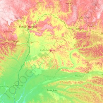
Name: Sud-Ubangi topographic map, elevation, terrain.
Location: Sud-Ubangi, Democratic Republic of the Congo (0.65595 17.14838 5.85595 22.34838)
Average elevation: 1,381 ft
Minimum elevation: 997 ft
Maximum elevation: 2,470 ft
Make a donation
Gear up for your next adventure:
As an Amazon Associate, this site earns from qualifying purchases at no extra cost to you.
Other topographic maps
Click on a map to view its topography, its elevation and its terrain.
North Kivu
Democratic Republic of the Congo
Situated along the equator, North Kivu spans latitudes from 0° 58' north to 2° 03' south and longitudes from 27° 14' west to 29° 58' east. Its topography ranges from less than 800 meters to peaks exceeding 5,000 meters in altitude, comprising diverse formations including plains, plateaus, and mountainous…
Average elevation: 3,901 ft
Lubumbashi
Democratic Republic of the Congo > Haut-Katanga > Ville de Lubumbashi
Lubumbashi lies at around 1,208 m (3,963 ft) above sea level. The high altitude serves to cool the climate, which would otherwise be very hot. The Kafue River rises along the Zambian border near the city and meanders through north-central Zambia to the Zambezi River, cutting a long, deep panhandle into the…
Average elevation: 4,098 ft
Make a donation
Gear up for your next adventure:
As an Amazon Associate, this site earns from qualifying purchases at no extra cost to you.
Lake Tanganyika
Democratic Republic of the Congo
The lake has a complex history of changing flow patterns, due to its high altitude, great depth, slow rate of refill, and mountainous location in a turbulently volcanic area that has undergone climate changes. Apparently, it has rarely in the past had an outflow to the sea. It has been described as…
Average elevation: 3,491 ft
Make a donation
Gear up for your next adventure:
As an Amazon Associate, this site earns from qualifying purchases at no extra cost to you.
Kilwa
Democratic Republic of the Congo > Haut-Katanga > Ville de Lubumbashi > Lubumbashi
Average elevation: 4,016 ft
Make a donation
Gear up for your next adventure:
As an Amazon Associate, this site earns from qualifying purchases at no extra cost to you.
Make a donation
Gear up for your next adventure:
As an Amazon Associate, this site earns from qualifying purchases at no extra cost to you.
Kimbembe
Democratic Republic of the Congo > Haut-Katanga > Ville de Lubumbashi
Average elevation: 4,137 ft
Lusambo
Democratic Republic of the Congo > Kasai-Oriental > Ville de Mbujimayi
Average elevation: 1,955 ft
Make a donation
Gear up for your next adventure:
As an Amazon Associate, this site earns from qualifying purchases at no extra cost to you.
Kinkole
Democratic Republic of the Congo > Haut-Katanga > Ville de Lubumbashi > Lubumbashi
Average elevation: 3,980 ft
Make a donation
Gear up for your next adventure:
As an Amazon Associate, this site earns from qualifying purchases at no extra cost to you.
Make a donation
Gear up for your next adventure:
As an Amazon Associate, this site earns from qualifying purchases at no extra cost to you.
Make a donation
Gear up for your next adventure:
As an Amazon Associate, this site earns from qualifying purchases at no extra cost to you.
Naviundu
Democratic Republic of the Congo > Haut-Katanga > Ville de Lubumbashi > Naviundu
Average elevation: 4,049 ft
Lava Lake of Mount Nyiragongo
Democratic Republic of the Congo > North Kivu > Nyiragongo
Average elevation: 10,118 ft
Make a donation
Gear up for your next adventure:
As an Amazon Associate, this site earns from qualifying purchases at no extra cost to you.
Make a donation
Gear up for your next adventure:
As an Amazon Associate, this site earns from qualifying purchases at no extra cost to you.