Geolocate

Southgate topographic map

Click on the map to display elevation.

About this map

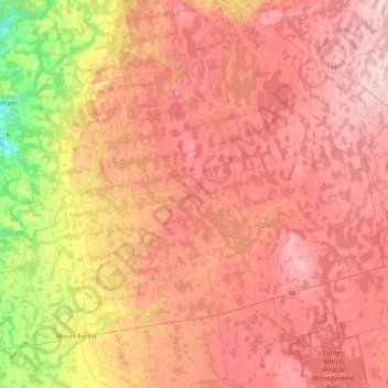
Name: Southgate topographic map, elevation, terrain.

Location: Southgate, Grey County, Ontario, Canada (43.98138 -80.81371 44.21773 -80.36090)

Average elevation: 1,506 ft

Minimum elevation: 1,079 ft

Maximum elevation: 1,765 ft

Other topographic maps

Click on a map to view its topography, its elevation and its terrain.

Holstein

Canada > Ontario > Grey County > Southgate

Average elevation: 1,345 ft

Singhampton

Canada > Ontario > Grey County > Grey Highlands

Average elevation: 1,660 ft

Clarksburg

Canada > Ontario > Grey County > The Blue Mountains

Average elevation: 692 ft

The Blue Mountains

Canada > Ontario > Grey County

Average elevation: 869 ft

Kemble

Canada > Ontario > Grey County > Georgian Bluffs

Average elevation: 797 ft

Neustadt

Canada > Ontario > Grey County > West Grey

Average elevation: 988 ft

Ayton

Canada > Ontario > Grey County > West Grey

Average elevation: 1,102 ft

Owen Sound

Canada > Ontario > Grey County > Owen Sound

Average elevation: 846 ft

Gear up for your next adventure:

🪄Magnetic Compass - Accurate compass for navigation
🌡️Portable Weather Meter - Track weather conditions on the trail
🪓Survival Multi‑Tool - Versatile tool for camp and trail tasks
🧤Hiking Gloves - Protective gloves for rugged trails
🎒Waterproof Dry Bags - Keep your electronics and maps dry inside your pack

As an Amazon Associate, this site earns from qualifying purchases at no extra cost to you.