
Norfolk topographic map
Click on the map to display elevation.
Norfolk
According to the United States Census Bureau, the town has a total area of 46.4 square miles (120.2 km2), of which 45.3 square miles (117.4 km2) are land and 1.1 square miles (2.9 km2), or 2.38%, are water. The town is located in the Litchfield Hills portion of the Appalachian mountain range. Norfolk's elevation is 1,230 feet (370 m) above sea level, and the town is sometimes called "the Icebox of Connecticut" for its severe winters and particularly cool summers.
About this map
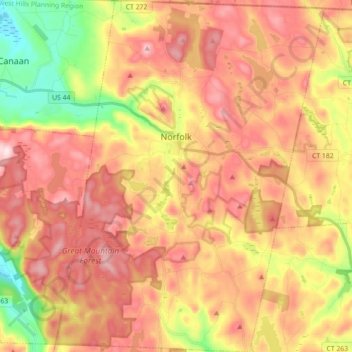
Name: Norfolk topographic map, elevation, terrain.
Average elevation: 1,325 ft
Minimum elevation: 666 ft
Maximum elevation: 1,834 ft
Northwest Hills Planning Region trails, hiking, mountain biking, running and outdoor activities
Other topographic maps
Click on a map to view its topography, its elevation and its terrain.
Apple Hill
United States > Connecticut > Northwest Hills Planning Region > Morris
Average elevation: 974 ft
Winchester Center
United States > Connecticut > Northwest Hills Planning Region > Winchester
Average elevation: 1,263 ft
Northfield
United States > Connecticut > Northwest Hills Planning Region > Litchfield
Average elevation: 850 ft
Bakerville
United States > Connecticut > Northwest Hills Planning Region > New Hartford
Average elevation: 801 ft
Haystack Mountain
United States > Connecticut > Northwest Hills Planning Region > Norfolk
Average elevation: 1,263 ft
Marble Dale
United States > Connecticut > Northwest Hills Planning Region > Washington
Average elevation: 817 ft
Washington Depot
United States > Connecticut > Northwest Hills Planning Region > Washington
Average elevation: 758 ft
Nelsons Corner
United States > Connecticut > Northwest Hills Planning Region > Winchester
Average elevation: 902 ft
Nepaug
United States > Connecticut > Northwest Hills Planning Region > New Hartford
Average elevation: 728 ft
West Torrington
United States > Connecticut > Northwest Hills Planning Region > Torrington
Average elevation: 886 ft
Canaan Valley
United States > Connecticut > Northwest Hills Planning Region > North Canaan
Average elevation: 961 ft
Lakeville
United States > Connecticut > Northwest Hills Planning Region > Salisbury
Average elevation: 850 ft
Roxbury Falls
United States > Connecticut > Northwest Hills Planning Region > Roxbury
Average elevation: 492 ft
East Morris
United States > Connecticut > Northwest Hills Planning Region > Morris
Average elevation: 965 ft
Wangum Village
United States > Connecticut > Northwest Hills Planning Region > Canaan
Average elevation: 771 ft
Browns Corner
United States > Connecticut > Northwest Hills Planning Region > New Hartford
Average elevation: 696 ft
Pleasant Valley
United States > Connecticut > Northwest Hills Planning Region > Barkhamsted
Average elevation: 630 ft
Drakeville
United States > Connecticut > Northwest Hills Planning Region > Torrington
Average elevation: 1,014 ft
Lookout
United States > Connecticut > Northwest Hills Planning Region > Goshen
Average elevation: 1,424 ft
Bartholomew Hill
United States > Connecticut > Northwest Hills Planning Region > Goshen
Average elevation: 1,398 ft
Taconic
United States > Connecticut > Northwest Hills Planning Region > Salisbury
Average elevation: 784 ft
Yellow Mountain
United States > Connecticut > Northwest Hills Planning Region > New Hartford
Average elevation: 732 ft
Bear Mountain
United States > Connecticut > Northwest Hills Planning Region > Salisbury
Bear Mountain is a peak of the southern Taconic Mountains in Salisbury, Connecticut. At 2,316 feet (706 m) (note, per references 1 and 3, there is disagreement about the precise elevation), Bear Mountain is the highest mountain that lies wholly within Connecticut. However, it is not the state highpoint: in the…
Average elevation: 1,785 ft
The Matterhorn
United States > Connecticut > Northwest Hills Planning Region > Canaan
Average elevation: 1,516 ft
Bear Mountain
United States > Connecticut > Northwest Hills Planning Region > Salisbury
Bear Mountain is a peak of the southern Taconic Mountains in Salisbury, Connecticut. At 2,316 feet (706 m) (note, per references 1 and 3, there is disagreement about the precise elevation), Bear Mountain is the highest mountain that lies wholly within Connecticut. However, it is not the state highpoint: in the…
Average elevation: 1,785 ft
Torringford
United States > Connecticut > Northwest Hills Planning Region > Torrington
Average elevation: 988 ft
Canaan Valley
United States > Connecticut > Northwest Hills Planning Region > North Canaan
Average elevation: 961 ft
The Matterhorn
United States > Connecticut > Northwest Hills Planning Region > Canaan
Average elevation: 1,516 ft
Lime Rock
United States > Connecticut > Northwest Hills Planning Region > Salisbury
Average elevation: 781 ft
Apple Hill
United States > Connecticut > Northwest Hills Planning Region > Morris
Average elevation: 974 ft
Bulls Bridge
United States > Connecticut > Northwest Hills Planning Region > Kent
Average elevation: 584 ft
Bear Mountain
United States > Connecticut > Northwest Hills Planning Region > Salisbury
Bear Mountain is a peak of the southern Taconic Mountains in Salisbury, Connecticut. At 2,316 feet (706 m) (note, per references 1 and 3, there is disagreement about the precise elevation), Bear Mountain is the highest mountain that lies wholly within Connecticut. However, it is not the state highpoint: in the…
Average elevation: 1,785 ft
Grand Staircase
United States > Connecticut > Northwest Hills Planning Region > Kent
Average elevation: 673 ft
Northfield
United States > Connecticut > Northwest Hills Planning Region > Litchfield
Average elevation: 850 ft
Bradford Mountain
United States > Connecticut > Northwest Hills Planning Region > Canaan
Average elevation: 1,542 ft
Panorama Hill
United States > Connecticut > Northwest Hills Planning Region > Colebrook
Average elevation: 1,243 ft
Town Hill
United States > Connecticut > Northwest Hills Planning Region > New Hartford
Average elevation: 837 ft
Milton Hill
United States > Connecticut > Northwest Hills Planning Region > Goshen
Average elevation: 1,207 ft
Northfield
United States > Connecticut > Northwest Hills Planning Region > Litchfield
Average elevation: 850 ft
Burrville
United States > Connecticut > Northwest Hills Planning Region > Torrington
Average elevation: 958 ft