Geolocate

Lakeland topographic map

Click on the map to display elevation.

About this map

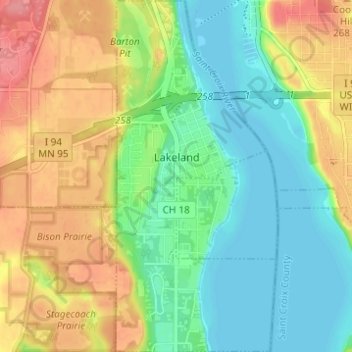
Name: Lakeland topographic map, elevation, terrain.

Location: Lakeland, Washington County, Minnesota, 55043, United States (44.93084 -92.78164 44.97440 -92.75343)

Average elevation: 774 ft

Minimum elevation: 669 ft

Maximum elevation: 928 ft

Washington County trails, hiking, mountain biking, running and outdoor activities

Other topographic maps

Click on a map to view its topography, its elevation and its terrain.

Hugo

United States > Minnesota > Washington County > Hugo > Hugo

Average elevation: 935 ft

Oakdale

United States > Minnesota > Washington County > Oakdale > Oakdale

Average elevation: 994 ft

Afton

United States > Minnesota > Washington County > Afton > Afton

Average elevation: 804 ft

Scandia

United States > Minnesota > Washington County > Scandia > Scandia

Average elevation: 1,010 ft

Gear up for your next adventure:

🏥Hiking First Aid Kits - Comprehensive medical kits for remote trail injuries
🎒Trail Energy Bars - High‑calorie bars for hiking energy
🧥Men's Rain Shells - Premium waterproof and breathable jackets for mountain weather
❄️Traction Cleats - Prevent slips on icy trails during winter hikes
🚪Portable Camp Chair - Foldable chair for comfort at camp

As an Amazon Associate, this site earns from qualifying purchases at no extra cost to you.