
Make a donation
Gear up for your next adventure:
As an Amazon Associate, this site earns from qualifying purchases at no extra cost to you.
Okavango River topographic map
Click on the map to display elevation.
Make a donation
Gear up for your next adventure:
As an Amazon Associate, this site earns from qualifying purchases at no extra cost to you.
Okavango River
The Okavango River (formerly spelled Okovango or Okovanggo), Also known as the Cubango River, is a river in southwest Africa. It is the fourth-longest river system in southern Africa, running southeastward for 1,600 km (1,000 mi). It begins at an elevation of 1,300 metres (4,300 ft) in the sandy highlands of Angola. Farther south, it forms part of the border between Angola and Namibia, and then flows into Botswana. The Okavango does not have an outlet to the sea. Instead, it discharges into the Okavango Delta or Okavango Alluvial Fan, in an endorheic basin in the Kalahari Desert.
Make a donation
Gear up for your next adventure:
As an Amazon Associate, this site earns from qualifying purchases at no extra cost to you.
About this map
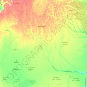
Name: Okavango River topographic map, elevation, terrain.
Location: Okavango River, Angola (-18.98829 16.08085 -12.61569 22.57846)
Average elevation: 4,137 ft
Minimum elevation: 3,402 ft
Maximum elevation: 8,084 ft
Make a donation
Gear up for your next adventure:
As an Amazon Associate, this site earns from qualifying purchases at no extra cost to you.
Other topographic maps
Click on a map to view its topography, its elevation and its terrain.
Saurimo
Saurimo is located in northeastern Angola at an elevation of 1,084 m (3,556 ft) above sea level. It is a garrison town and local market center.
Average elevation: 3,497 ft
Cuito
The town sits on the eastern flank of the Bie Plateau. The climate is unusually cool for its tropical location. The average annual temperature is 18 °C, largely due to its high altitude. The coolest period is May to August when almost no rain falls. September and October are the hottest months with a little…
Average elevation: 5,482 ft
Make a donation
Gear up for your next adventure:
As an Amazon Associate, this site earns from qualifying purchases at no extra cost to you.
Make a donation
Gear up for your next adventure:
As an Amazon Associate, this site earns from qualifying purchases at no extra cost to you.
Make a donation
Gear up for your next adventure:
As an Amazon Associate, this site earns from qualifying purchases at no extra cost to you.