
Make a donation
Gear up for your next adventure:
As an Amazon Associate, this site earns from qualifying purchases at no extra cost to you.
Ponemah topographic map
Click on the map to display elevation.
Make a donation
Gear up for your next adventure:
As an Amazon Associate, this site earns from qualifying purchases at no extra cost to you.
About this map
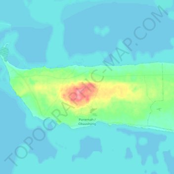
Name: Ponemah topographic map, elevation, terrain.
Location: Ponemah, Beltrami County, Minnesota, 56666, United States (48.01355 -95.00636 48.07644 -94.82388)
Average elevation: 1,188 ft
Minimum elevation: 1,158 ft
Maximum elevation: 1,404 ft
Beltrami County trails, hiking, mountain biking, running and outdoor activities
Make a donation
Gear up for your next adventure:
As an Amazon Associate, this site earns from qualifying purchases at no extra cost to you.
Other topographic maps
Click on a map to view its topography, its elevation and its terrain.
Make a donation
Gear up for your next adventure:
As an Amazon Associate, this site earns from qualifying purchases at no extra cost to you.
Big Bog State Recreation Area
United States > Minnesota > Beltrami County > Waskish
Average elevation: 1,178 ft