Geolocate

Waskish topographic map

Click on the map to display elevation.

About this map

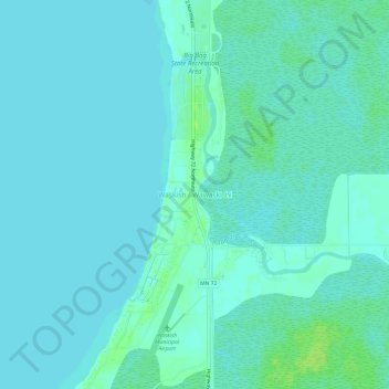
Name: Waskish topographic map, elevation, terrain.

Location: Waskish, Beltrami County, Minnesota, 56685, United States (48.14135 -94.53246 48.18135 -94.49246)

Average elevation: 1,178 ft

Minimum elevation: 1,168 ft

Maximum elevation: 1,204 ft

Beltrami County trails, hiking, mountain biking, running and outdoor activities

Other topographic maps

Click on a map to view its topography, its elevation and its terrain.

Ponemah

United States > Minnesota > Beltrami County

Average elevation: 1,188 ft

Movil Lake Dam

United States > Minnesota > Beltrami County

Average elevation: 1,365 ft

Green Lake

United States > Minnesota > Beltrami County > Little Rock

Average elevation: 1,243 ft

Solway

United States > Minnesota > Beltrami County > Solway

Average elevation: 1,444 ft

Long Lake

United States > Minnesota > Beltrami County

Average elevation: 1,378 ft

Little Rock

United States > Minnesota > Beltrami County

Average elevation: 1,230 ft

Gear up for your next adventure:

😴Insulated Sleeping Pads - Compact and warm pads for high-elevation camping
🔦Powerful Headlamps - Ultra-bright hands-free lighting for night navigation
🥾Men's Hiking Boots - Durable, waterproof footwear for rugged terrain and steep inclines
🩹Survival Bandages - High‑quality bandages for emergencies
🎒Hydration Pack - Hands‑free water reservoir for long hikes

As an Amazon Associate, this site earns from qualifying purchases at no extra cost to you.