Geolocate

Long Lake topographic map

Click on the map to display elevation.

About this map

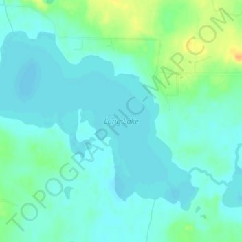
Name: Long Lake topographic map, elevation, terrain.

Location: Long Lake, Beltrami County, Minnesota, United States (47.64219 -94.99671 47.66230 -94.95794)

Average elevation: 1,378 ft

Minimum elevation: 1,348 ft

Maximum elevation: 1,457 ft

Beltrami County trails, hiking, mountain biking, running and outdoor activities

Other topographic maps

Click on a map to view its topography, its elevation and its terrain.

Ponemah

United States > Minnesota > Beltrami County

Average elevation: 1,188 ft

Little Rock

United States > Minnesota > Beltrami County

Average elevation: 1,230 ft

Waskish

United States > Minnesota > Beltrami County

Average elevation: 1,178 ft

Bemidji

United States > Minnesota > Beltrami County > Bemidji

Average elevation: 1,365 ft

Solway

United States > Minnesota > Beltrami County > Solway

Average elevation: 1,444 ft

Gear up for your next adventure:

🧦Merino Wool Socks - Moisture-wicking, blister-preventing socks for long treks
🎒Waterproof Dry Bags - Keep your electronics and maps dry inside your pack
🎁Geography Themed Gifts - Unique gift ideas for map lovers and geography enthusiasts
🥤Water Filter Bottle - All‑in‑one filter bottle for safe hydration
🪶Thermal Camp Blanket - Extra warmth for cold nights

As an Amazon Associate, this site earns from qualifying purchases at no extra cost to you.