
Province of Satipo topographic map
Interactive map
Click on the map to display elevation.
About this map
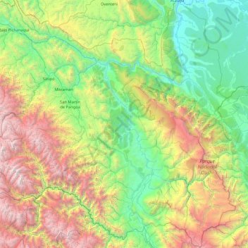
Name: Province of Satipo topographic map, elevation, terrain.
Location: Province of Satipo, Junín, 12260, Peru (-12.38699 -75.05100 -10.73401 -73.35513)
Average elevation: 5,115 ft
Minimum elevation: 669 ft
Maximum elevation: 17,014 ft
Other topographic maps
Click on a map to view its topography, its elevation and its terrain.
Barrio Independencia
Barrio Independencia, San José de Quero, Province of Concepción, Junín, Peru
Average elevation: 13,081 ft
Chanchamayo
Peru > Junín > Santo Domingo de Acobamba > Chanchamayo
Chanchamayo, Santo Domingo de Acobamba, Province of Huancayo, Junín, Peru
Average elevation: 8,471 ft
Carhuamayo
Peru > Junín > Carhuamayo
Carhuamayo, Province of Junín, Junín, Peru
Average elevation: 13,937 ft