
Lydham topographic map
Click on the map to display elevation.
About this map
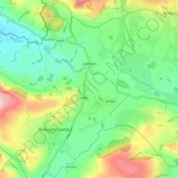
Name: Lydham topographic map, elevation, terrain.
Location: Lydham, Shropshire, England, United Kingdom (52.47997 -3.03671 52.53198 -2.94722)
Average elevation: 663 ft
Minimum elevation: 423 ft
Maximum elevation: 1,109 ft
Other topographic maps
Click on a map to view its topography, its elevation and its terrain.
Minton
United Kingdom > England > Shropshire > Church Stretton > Little Stretton
Average elevation: 892 ft
Cothercott Hill
United Kingdom > England > Shropshire > Church Pulverbatch
Average elevation: 1,122 ft