Geolocate

Quinua topographic map

Click on the map to display elevation.

About this map

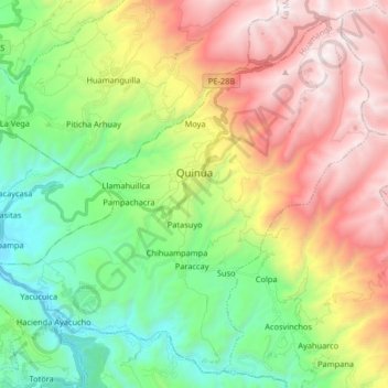
Name: Quinua topographic map, elevation, terrain.

Location: Quinua, Huamanga, Ayacucho, Peru (-13.13163 -74.22920 -12.98495 -74.06590)

Average elevation: 10,709 ft

Minimum elevation: 8,038 ft

Maximum elevation: 14,557 ft

Other topographic maps

Click on a map to view its topography, its elevation and its terrain.

Infantes

Peru > Ayacucho

Average elevation: 8,202 ft

Anoccara Pampa

Peru > Ayacucho > Canaria

Average elevation: 14,226 ft

Fortaleza

Peru > Ayacucho

Average elevation: 2,260 ft

Cochas Baja

Peru > Ayacucho > San Miguel

Average elevation: 10,876 ft

Chonta

Peru > Ayacucho > Querobamba

Average elevation: 9,882 ft

La Vega

Peru > Ayacucho

Average elevation: 9,459 ft

San Jose

Peru > Ayacucho

Average elevation: 4,301 ft

Atto

Peru > Ayacucho > Paras > Atto

Average elevation: 13,438 ft

Gear up for your next adventure:

🎒Day Hiking Backpack - Lightweight backpack perfect for day trips and outdoor adventures
🦶Hiking Gaiters - Keep debris and water out of your boots
🧼Biodegradable Camping Soap - Eco‑friendly soap for outdoor hygiene
🪓Survival Multi‑Tool - Versatile tool for camp and trail tasks
🧭Compass with Lanyard - Easy‑carry compass for navigation

As an Amazon Associate, this site earns from qualifying purchases at no extra cost to you.