Geolocate

Bryant topographic map

Click on the map to display elevation.

About this map

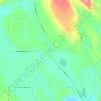
Name: Bryant topographic map, elevation, terrain.

Location: Bryant, Snohomish County, Washington, United States (48.21899 -122.17792 48.25899 -122.13792)

Average elevation: 207 ft

Minimum elevation: 49 ft

Maximum elevation: 561 ft

Snohomish County trails, hiking, mountain biking, running and outdoor activities

Other topographic maps

Click on a map to view its topography, its elevation and its terrain.

Esperance

United States > Washington > Snohomish County > Esperance

Average elevation: 387 ft

Lochsloy

United States > Washington > Snohomish County

Average elevation: 367 ft

Lake Stickney

United States > Washington > Snohomish County

Average elevation: 3,625 ft

Brier

United States > Washington > Snohomish County

Average elevation: 344 ft

Bowser Lake

United States > Washington > Snohomish County

Average elevation: 4,570 ft

Martha Lake

United States > Washington > Snohomish County

Average elevation: 433 ft

North Creek

United States > Washington > Snohomish County

Average elevation: 325 ft

Verlot

United States > Washington > Snohomish County

Average elevation: 2,336 ft

Dagger Lake

United States > Washington > Snohomish County

Average elevation: 965 ft

Gear up for your next adventure:

💧Water Filtration Bottles - Safely drink from streams and lakes while exploring
🪶Paracord Bracelet - Survival bracelet with built‑in tools
🗻Climbing Gear Basics - Essential gear for beginner climbers
🧴Hand Sanitizer - Keep hands clean while hiking
🍳Camping Cook Set - Complete cookware for outdoor meals

As an Amazon Associate, this site earns from qualifying purchases at no extra cost to you.