Geolocate

Cavetown topographic map

Interactive map

Click on the map to display elevation.

About this map

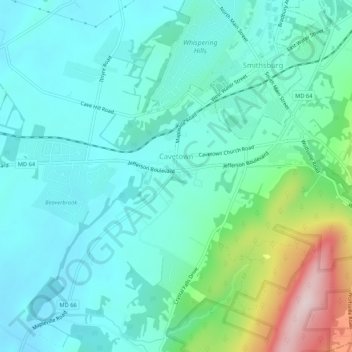
Name: Cavetown topographic map, elevation, terrain.

Location: Cavetown, Washington County, Maryland, 21720, United States (39.63124 -77.62298 39.65260 -77.57009)

Average elevation: 850 ft

Minimum elevation: 591 ft

Maximum elevation: 1,808 ft

Washington County trails, hiking, mountain biking, running and outdoor activities

Other topographic maps

Click on a map to view its topography, its elevation and its terrain.

Antietam

United States > Maryland > Washington County

Average elevation: 404 ft

Long Meadow

United States > Maryland > Washington County

Average elevation: 630 ft

Weverton

United States > Maryland > Washington County

Average elevation: 502 ft

Cascade

United States > Maryland > Washington County

Average elevation: 1,430 ft

Pleasant Valley

United States > Maryland > Washington County

Average elevation: 1,516 ft

Dargan

United States > Maryland > Washington County

Average elevation: 518 ft

Hancock

United States > Maryland > Washington County > Hancock > Hancock

Average elevation: 545 ft

Hillside

United States > Maryland > Washington County > Hillside

Average elevation: 594 ft