Geolocate

Long Meadow topographic map

Click on the map to display elevation.

About this map

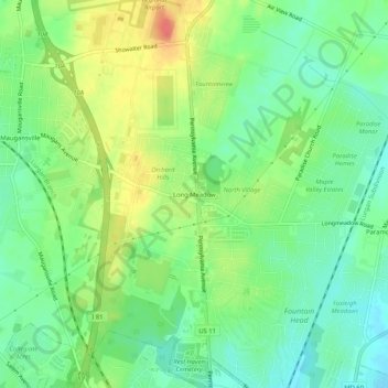
Name: Long Meadow topographic map, elevation, terrain.

Location: Long Meadow, Washington County, Maryland, 21767, United States (39.66700 -77.74139 39.70700 -77.70139)

Average elevation: 630 ft

Minimum elevation: 554 ft

Maximum elevation: 745 ft

Washington County trails, hiking, mountain biking, running and outdoor activities

Other topographic maps

Click on a map to view its topography, its elevation and its terrain.

Williamsport

United States > Maryland > Washington County

Average elevation: 417 ft

Halfway

United States > Maryland > Washington County

Average elevation: 561 ft

St. James

United States > Maryland > Washington County

Average elevation: 512 ft

Cavetown

United States > Maryland > Washington County

Average elevation: 850 ft

Robinwood

United States > Maryland > Washington County > Robinwood

Average elevation: 574 ft

Keedysville

United States > Maryland > Washington County

Average elevation: 423 ft

Gear up for your next adventure:

🦶Hiking Gaiters - Keep debris and water out of your boots
🥾Women's Hiking Boots - Top-rated trail boots with ankle support and superior grip
🌧️Backpack Rain Cover - Keep gear dry in wet weather
🔊Portable Camp Speaker - Music and alerts at camp
📱Solar Portable Charger - Solar power bank for charging devices off‑grid

As an Amazon Associate, this site earns from qualifying purchases at no extra cost to you.