
Make a donation
Gear up for your next adventure:
As an Amazon Associate, this site earns from qualifying purchases at no extra cost to you.
Sonnen topographic map
Click on the map to display elevation.
Make a donation
Gear up for your next adventure:
As an Amazon Associate, this site earns from qualifying purchases at no extra cost to you.
Sonnen
Sonnen liegt in der Region Donau-Wald im unteren Bayerischen Wald und ist die höchstgelegene Gemeinde im Landkreis Passau auf einer Höhe von 700 bis 900 Metern. Nach Passau sind es 28 km, nach Hauzenberg 9 km und Waldkirchen bzw. Wegscheid jeweils 13 km. Die Grenze zu Oberösterreich liegt nur 8 km entfernt.
Make a donation
Gear up for your next adventure:
As an Amazon Associate, this site earns from qualifying purchases at no extra cost to you.
About this map
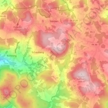
Name: Sonnen topographic map, elevation, terrain.
Location: Sonnen, Landkreis Passau, Bayern, 94164, Deutschland (48.64211 13.67590 48.69217 13.75993)
Average elevation: 2,556 ft
Minimum elevation: 1,903 ft
Maximum elevation: 2,936 ft
Make a donation
Gear up for your next adventure:
As an Amazon Associate, this site earns from qualifying purchases at no extra cost to you.
Other topographic maps
Click on a map to view its topography, its elevation and its terrain.
Forsthub
Deutschland > Bayern > Landkreis Passau > Bad Griesbach i.Rottal > St. Salvator
Average elevation: 1,394 ft
Haidenhof
Deutschland > Bayern > Landkreis Passau > Hauzenberg > Ruhmannsdorf
Average elevation: 1,808 ft
Make a donation
Gear up for your next adventure:
As an Amazon Associate, this site earns from qualifying purchases at no extra cost to you.
Make a donation
Gear up for your next adventure:
As an Amazon Associate, this site earns from qualifying purchases at no extra cost to you.
Grafenmühl
Deutschland > Bayern > Landkreis Passau > Vilshofen an der Donau > Liessing
Average elevation: 1,161 ft
Make a donation
Gear up for your next adventure:
As an Amazon Associate, this site earns from qualifying purchases at no extra cost to you.
Make a donation
Gear up for your next adventure:
As an Amazon Associate, this site earns from qualifying purchases at no extra cost to you.
Kaltrum
Deutschland > Bayern > Landkreis Passau > Hauzenberg > Hintertiessen
Average elevation: 2,064 ft
Make a donation
Gear up for your next adventure:
As an Amazon Associate, this site earns from qualifying purchases at no extra cost to you.
Gottsdorf
Deutschland > Bayern > Landkreis Passau
Bachhäusl | Berghof | Brunnreut | Dienberg | Diendorf | Dürrmühle | Eck | Eckersäg | Eckerstampf | Eckmühle | Endsfelden | Feldhäusl | Ficht | Fichtwiesen | Friedlgrub | Gammertshof | Gebrechtshof | Gebrechtsmühle | Glotzing | Gotting | Gottsdorf | Grögöd | Grub | Grünau | Habersdorf | Hamet |…
Average elevation: 1,900 ft
Make a donation
Gear up for your next adventure:
As an Amazon Associate, this site earns from qualifying purchases at no extra cost to you.
Jägerwirth
Deutschland > Bayern > Landkreis Passau
Jägerwirth liegt in einer Höhenlage von 476 Metern am Rand des Neuburger Waldes etwa drei Kilometer nordwestlich von Fürstenzell. Die Pfarrkirche des Ortes ist über mehrere Kilometer zu sehen.
Average elevation: 1,394 ft
Kramersdorf
Deutschland > Bayern > Landkreis Passau > Hauzenberg > Raßreuth
Average elevation: 2,064 ft
Make a donation
Gear up for your next adventure:
As an Amazon Associate, this site earns from qualifying purchases at no extra cost to you.
Steinkart
Deutschland > Bayern > Landkreis Passau > Bad Griesbach i.Rottal
Average elevation: 1,476 ft
Make a donation
Gear up for your next adventure:
As an Amazon Associate, this site earns from qualifying purchases at no extra cost to you.
Make a donation
Gear up for your next adventure:
As an Amazon Associate, this site earns from qualifying purchases at no extra cost to you.
Adlmörting
Deutschland > Bayern > Landkreis Passau > Bad Griesbach i.Rottal > Reutern
Average elevation: 1,437 ft
Make a donation
Gear up for your next adventure:
As an Amazon Associate, this site earns from qualifying purchases at no extra cost to you.
Reut
Deutschland > Bayern > Landkreis Passau > Vilshofen an der Donau > Aunkirchen
Average elevation: 1,155 ft
Sollasöd
Deutschland > Bayern > Landkreis Passau > Vilshofen an der Donau > Lindach
Average elevation: 1,175 ft
Make a donation
Gear up for your next adventure:
As an Amazon Associate, this site earns from qualifying purchases at no extra cost to you.
Unteriglbach
Deutschland > Bayern > Landkreis Passau > Ortenburg
Wie alle auf -bach endenden Orte bezeichnet auch der Name Iglbach zunächst ein Gewässer, an dem die Siedlung liegt. Die „-bach“-Orte gelten als Zeugen frühen Eindringens ins Waldland. In der Topographie Baierns von Philipp Apian, welche um das Jahr 1580 in lateinischer Sprache entstand, wird das Dorf…
Average elevation: 1,224 ft
Make a donation
Gear up for your next adventure:
As an Amazon Associate, this site earns from qualifying purchases at no extra cost to you.
Make a donation
Gear up for your next adventure:
As an Amazon Associate, this site earns from qualifying purchases at no extra cost to you.
Make a donation
Gear up for your next adventure:
As an Amazon Associate, this site earns from qualifying purchases at no extra cost to you.
Make a donation
Gear up for your next adventure:
As an Amazon Associate, this site earns from qualifying purchases at no extra cost to you.
Eisenthal
Deutschland > Bayern > Landkreis Passau > Bad Griesbach i.Rottal > Singham
Average elevation: 1,181 ft
Make a donation
Gear up for your next adventure:
As an Amazon Associate, this site earns from qualifying purchases at no extra cost to you.
Alkofen
Deutschland > Bayern > Landkreis Passau > Vilshofen an der Donau
Alkofen entstand aus den Bestrebungen des bayerischen Kurfürsten, seine Länder zu „peupelieren“, das heißt, auf öffentlichem Grund Siedlerstellungen zu schaffen, bäuerliche Kleinbetriebe, die eine Familie ernähren sollten. Vor 1800 gab es nur die Weiler Alkofen, Daxlarn, Dorf, einige Einödhöfe und…
Average elevation: 1,224 ft
Bad Höhenstadt
Deutschland > Bayern > Landkreis Passau
Bad Höhenstadt ist ein Gemeindeteil, ehemaliger Wallfahrtsort und ehemaliger Kurort im Markt Fürstenzell im niederbayerischen Landkreis Passau.
Average elevation: 1,184 ft
Make a donation
Gear up for your next adventure:
As an Amazon Associate, this site earns from qualifying purchases at no extra cost to you.
Neumühle
Deutschland > Bayern > Landkreis Passau > Hauzenberg > Innerhartsberg
Average elevation: 1,480 ft
Make a donation
Gear up for your next adventure:
As an Amazon Associate, this site earns from qualifying purchases at no extra cost to you.
Make a donation
Gear up for your next adventure:
As an Amazon Associate, this site earns from qualifying purchases at no extra cost to you.
Make a donation
Gear up for your next adventure:
As an Amazon Associate, this site earns from qualifying purchases at no extra cost to you.
Kollbrunn
Deutschland > Bayern > Landkreis Passau > Fürstenzell > Kollbrunn
Average elevation: 1,362 ft
Hauzenberg
Deutschland > Bayern > Landkreis Passau > Hauzenberg > Hauzenberg
Average elevation: 1,952 ft
Make a donation
Gear up for your next adventure:
As an Amazon Associate, this site earns from qualifying purchases at no extra cost to you.
Singham
Deutschland > Bayern > Landkreis Passau > Bad Griesbach i.Rottal > Karpfham > Singham
Average elevation: 1,184 ft
Amsham
Deutschland > Bayern > Landkreis Passau > Bad Griesbach i.Rottal > Weng
Average elevation: 1,352 ft
Make a donation
Gear up for your next adventure:
As an Amazon Associate, this site earns from qualifying purchases at no extra cost to you.
Oberham
Deutschland > Bayern > Landkreis Passau > Bad Griesbach i.Rottal > Schwaim
Average elevation: 1,194 ft
Make a donation
Gear up for your next adventure:
As an Amazon Associate, this site earns from qualifying purchases at no extra cost to you.
Thal
Deutschland > Bayern > Landkreis Passau > Ortenburg > Neustift > Thal
Average elevation: 1,247 ft
Make a donation
Gear up for your next adventure:
As an Amazon Associate, this site earns from qualifying purchases at no extra cost to you.
Egglfing am Inn
Deutschland > Bayern > Landkreis Passau > Bad Füssing > Egglfing am Inn
Average elevation: 1,073 ft
Hilgartsberg
Deutschland > Bayern > Landkreis Passau > Gelbersdorf > Hilgartsberg
Average elevation: 1,240 ft
Schönerting
Deutschland > Bayern > Landkreis Passau > Vilshofen an der Donau > Schönerting
Average elevation: 1,122 ft
Make a donation
Gear up for your next adventure:
As an Amazon Associate, this site earns from qualifying purchases at no extra cost to you.