
Leyhill Common topographic map
Click on the map to display elevation.
About this map
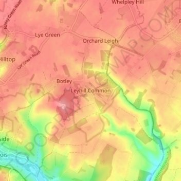
Name: Leyhill Common topographic map, elevation, terrain.
Average elevation: 482 ft
Minimum elevation: 289 ft
Maximum elevation: 574 ft
Other topographic maps
Click on a map to view its topography, its elevation and its terrain.
Chilterns National Landscape
United Kingdom > England > Buckinghamshire
The highest point is at 267 m (876 ft.) above sea level at Haddington Hill near Wendover in Buckinghamshire; a stone monument marks the summit. The nearby Ivinghoe Beacon is a more prominent hill, although its altitude is only 249 m (817 ft.). It is the starting point of the Icknield Way Path and the Ridgeway…
Average elevation: 335 ft
Preston Bissett
United Kingdom > England > Buckinghamshire > Preston Bissett
Average elevation: 318 ft
Chiltern District
United Kingdom > England > Buckinghamshire > Buckland Common
Average elevation: 449 ft
Aylesbury
United Kingdom > England > Buckinghamshire
Aylesbury is immediately southeast of the upper River Thame that flows past Thame to Dorchester on Thames and is partly sited on the two northernmost outcrops of Portland (lime)stone in England bisected by a small stream, Bear Brook which gives a relatively prominent position in relation to the terrain of all…
Average elevation: 279 ft
Weston Turville
United Kingdom > England > Buckinghamshire > Weston Turville
Average elevation: 322 ft
Drayton Parslow
United Kingdom > England > Buckinghamshire > Drayton Parslow
Average elevation: 384 ft