Geolocate

Tigris River topographic map

Click on the map to display elevation.

About this map

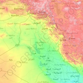
Name: Tigris River topographic map, elevation, terrain.

Location: Tigris River, Iraqi Kurdistan Region, Iraq (31.00471 39.45496 38.47892 47.45340)

Average elevation: 2,493 ft

Minimum elevation: 3 ft

Maximum elevation: 13,993 ft

Other topographic maps

Click on a map to view its topography, its elevation and its terrain.

Erbil

Iraq > Erbil Governorate

Average elevation: 1,516 ft

Karbala

Iraq > Karbala Governorate

Average elevation: 131 ft

Az Zubayr

Iraq > Basra Governorate

Average elevation: 26 ft

Duhok

Iraq > Duhok Governorate

Average elevation: 2,234 ft

Shekhan

Iraq > Erbil Governorate

Average elevation: 4,436 ft

Kalar

Iraq > Sulaymaniyah Governorate

Average elevation: 948 ft

Al-Faw

Iraq > Basra Governorate

Another view suggests that the name is derived from the city’s position at the mouth (fāh) of the Shatt al-Arab, which evolved linguistically into Faw. Some sources, however, argue that the original word was al-Faʾu (الفأو), meaning “open land visible to the eye” or “land enclosed between two elevations”.

Average elevation: 3 ft

Sheladiza

Iraq

Average elevation: 2,162 ft

Al-Faw

Iraq > Basra Governorate

Another view suggests that the name is derived from the city’s position at the mouth (fāh) of the Shatt al-Arab, which evolved linguistically into Faw. Some sources, however, argue that the original word was al-Faʾu (الفأو), meaning “open land visible to the eye” or “land enclosed between two elevations”.

Average elevation: 3 ft

Duhok

Iraq

Average elevation: 2,234 ft

Sidekan

Iraq > Erbil Governorate

Average elevation: 3,737 ft

Mawat

Iraq > Sulaymaniyah Governorate

Average elevation: 3,724 ft

Shaqlawa

Iraq > Erbil Governorate

Average elevation: 3,389 ft

Sangasar

Iraq > Sulaymaniyah Governorate

Average elevation: 1,857 ft

Kirkuk

Iraq > Kirkuk Governorate

Average elevation: 1,257 ft

Mosul

Iraq > Nineveh Governorate

Average elevation: 925 ft

The ancient city of Ur

Iraq > Dhi Qar Governorate > Ur

Average elevation: 20 ft

Basra

Iraq > Basra Governorate

Average elevation: 13 ft

Darbandikhan Dam

Iraq > Sulaymaniyah Governorate > Darbandikhan

The dam is located within a gorge on a foundation of sedimentary rocks. It is a rock-fill embankment type with a central clay core. The dam is 128 m (420 ft) tall and 445 m (1,460 ft) long (535 m (1,755 ft) if the spillway section is included). Its crest is 17 m (56 ft) wide and at an elevation of 495 m (1,624…

Average elevation: 1,873 ft

Soran

Iraq > Erbil Governorate

Average elevation: 2,500 ft

Dukan Dam

Iraq > Sulaymaniyah Governorate > Dukan

Average elevation: 1,690 ft

Fallujah

Iraq > Al-Anbar Governorate

Average elevation: 161 ft

Erbil

Iraq > Erbil Governorate

Average elevation: 1,516 ft

Al Hillah

Iraq > Babil Governorate

Average elevation: 95 ft

Said Sadiq

Iraq > Sulaymaniyah Governorate

Average elevation: 1,719 ft

As Samawah

Iraq > Muthanna Governorate

Average elevation: 43 ft

Sulaymaniyah

Iraq > Sulaymaniyah Governorate

Average elevation: 3,205 ft

Babylon

Iraq > Babil Governorate > Qaryat Annan

A topographical survey at the site was conducted in 1974, followed in 1977 by a review of the stratigraphical position of the main monuments and reconsideration of ancient water levels, by the Turin Centre for Archaeological Research and Excavations in the Middle East and Asia, and the Iraqi-Italian Institute…

Average elevation: 105 ft

Al Hillah

Iraq > Babil Governorate

Average elevation: 95 ft

Halabja

Iraq > Halabja Governorate > Halabja District

Halabja is located in the Shahrizor plain, a fertile valley nestled in the foothills of the Zagros Mountains in the Kurdistan Region of Iraq. The city's elevation is around 700 meters above sea level. The surrounding area is characterized by mountainous terrain, with the Hawraman Mountain range to the east,…

Average elevation: 2,956 ft

Hayy al-Auropa

Iraq > Nineveh Governorate > Mosul

Average elevation: 830 ft

Kalar

Iraq > Sulaymaniyah Governorate

Average elevation: 948 ft

Koy Sanjaq

Iraq > Erbil Governorate

Average elevation: 2,231 ft

Al-Najaf

Iraq > Al-Najaf Governorate

Average elevation: 98 ft

Sulaymaniyah

Iraq > Sulaymaniyah Governorate

Average elevation: 3,205 ft

Al Mahawil

Iraq > Babil Governorate

Average elevation: 98 ft

Akre

Iraq > Nineveh Governorate

Average elevation: 2,188 ft

Khayam

Iraq > Saladin Governorate

Average elevation: 190 ft

Basra

Iraq > Basra Governorate

Average elevation: 13 ft

Fallujah

Iraq > Al-Anbar Governorate

Average elevation: 161 ft

Barzan

Iraq > Erbil Governorate

Average elevation: 2,966 ft

Qada Raniyah

Iraq

Average elevation: 3,527 ft

Umm al Binni lake

Iraq

Based on the interpretation of satellite imagery, Sharad Master suggests the 3.4 km (2.1 mi) in diameter dry lake may be an impact crater based on its nearly circular, slightly polygonal rim shape, and contrasting shape to other lakes in the region. However, the circularity of its shape has been disputed, with…

Average elevation: 7 ft

Ramadi

Iraq > Al-Anbar Governorate

Average elevation: 203 ft

Mount Qandil

Iraq

Average elevation: 9,636 ft

Shaqlawa

Iraq > Erbil Governorate

Average elevation: 3,389 ft

Rubari Koya

Iraq > Erbil Governorate > Koy Sanjaq

Average elevation: 1,775 ft

Kani Panka

Iraq

Average elevation: 1,965 ft

Karbala

Iraq > Karbala Governorate

Average elevation: 131 ft

Maydan

Iraq > Sulaymaniyah Governorate > Surdash Subdistrict

Average elevation: 3,950 ft

Barzewa

Iraq > Erbil Governorate

Average elevation: 2,956 ft

Zirgoz

Iraq > Erbil Governorate

Average elevation: 2,779 ft

Haji Omaran

Iraq > Erbil Governorate

Average elevation: 6,801 ft

Bashiqa

Iraq > Nineveh Governorate

Average elevation: 1,312 ft

Cheekha Dar

Iraq > Erbil Governorate

It was climbed in November 2004 by English explorer Ginge Fullen, who recorded a GPS reading of 3,628 meters at the coordinates in the adjacent table. The location is consistent with SRTM and Russian topographic mapping, although these sources are more consistent with the CIA height.

Average elevation: 10,384 ft

Sheladize

Iraq

Average elevation: 2,949 ft

Banda

Iraq

Average elevation: 3,051 ft

Ranya

Iraq > Sulaymaniyah Governorate

Ranya is located in the Sulaymaniyah Governorate in the Kurdistan Region of Iraq, approximately 70 km northeast of Sulaymaniyah city. It is situated near the Hawraman Mountains and lies at an altitude of about 1,300 meters.

Average elevation: 2,224 ft

al-jabiria

Iraq > Saladin Governorate > Samarra

Average elevation: 256 ft

Greza

Iraq

Average elevation: 2,113 ft

Erbil

Iraq > Erbil Governorate

Average elevation: 1,516 ft

Kani Goma

Iraq

Average elevation: 2,369 ft

Hayy al-Auropa

Iraq > Nineveh Governorate > Mosul

Average elevation: 830 ft

Shive

Iraq > Erbil Governorate > Mergasur District

Average elevation: 4,157 ft

Al-Hirah

Iraq > Al-Najaf Governorate

Average elevation: 72 ft

Hit

Iraq > Al-Anbar Governorate

Average elevation: 305 ft

Zalan

Iraq

Average elevation: 4,058 ft

Bawageldy

Iraq

Average elevation: 2,582 ft

Choman

Iraq > Erbil Governorate

Average elevation: 4,741 ft

Qushtapa

Iraq > Erbil Governorate > Qushtapa District

Average elevation: 1,299 ft

Zawita

Iraq

Average elevation: 3,153 ft

Al-Najaf

Iraq > Al-Najaf Governorate

Average elevation: 98 ft

Chamchamal

Iraq > Sulaymaniyah Governorate

Average elevation: 2,421 ft

Duhok

Iraq

Average elevation: 2,234 ft

Sulaimaniya

Iraq > Al-Anbar Governorate

Average elevation: 400 ft

Piran

Iraq > Erbil Governorate

Average elevation: 3,284 ft

Saraw Lower

Iraq

Average elevation: 1,762 ft

Zargali

Iraq > Erbil Governorate

Average elevation: 2,264 ft

Hartal

Iraq

Average elevation: 4,708 ft

Dashtewan

Iraq

Average elevation: 3,750 ft

Athar an Namrud

Iraq > Babil Governorate > Umm Guzlah

Average elevation: 95 ft

Nasiriyah

Iraq > Dhi Qar Governorate

Average elevation: 16 ft

Kadar

Iraq

Average elevation: 1,407 ft

Majnoon island

Iraq

Average elevation: 13 ft

Hawshike

Iraq

Average elevation: 1,660 ft

Banda

Iraq

Average elevation: 3,051 ft

Al Kifl

Iraq > Babil Governorate

Average elevation: 89 ft

Dola Sur

Iraq

Average elevation: 3,127 ft

shiladiza

Iraq

Average elevation: 2,930 ft

Arab Ahmad Ibrahim

Iraq > Saladin Governorate

Average elevation: 262 ft

Khwaran

Iraq

Average elevation: 2,897 ft

Doli Khre

Iraq > Harir Subdistrict > Goska

Average elevation: 1,332 ft

An Nada

Iraq

Average elevation: 233 ft

Uruk

Iraq > Muthanna > As Samawah

Average elevation: 39 ft

Ranya

Iraq

Ranya is located in the Sulaymaniyah Governorate in the Kurdistan Region of Iraq, approximately 70 km northeast of Sulaymaniyah city. It is situated near the Hawraman Mountains and lies at an altitude of about 1,300 meters.

Average elevation: 2,224 ft

En Sifne

Iraq > Nineveh Governorate

Average elevation: 1,640 ft

Kalawanan

Iraq

Average elevation: 2,792 ft

Gear up for your next adventure:

🎁Geography Themed Gifts - Unique gift ideas for map lovers and geography enthusiasts
📡GPS Antenna Upgrade - Enhance GPS reception in remote terrain
🏔️Mountain Trail Maps - High‑detail maps for popular peaks
🪶LED Camping Lantern - Bright lantern for camp lighting
🪶Trail Camera - Capture wildlife on your hikes

As an Amazon Associate, this site earns from qualifying purchases at no extra cost to you.