Geolocate

Kirkcaldy topographic map

Click on the map to display elevation.

Kirkcaldy

Towards the end of the 16th century, a detailed assessment on the size of the townscape was carried out. The first estimate of the parish population in 1639 was between 3,000 and 3,200 and around 3,400 by 1691. At the beginning of the 18th century, the population declined. A census by Webster's Topographical Dictionary of Scotland in 1755, recorded an estimate of 2,296 in the parish. By the time of the first nationwide UK census in 1801, the population had risen to 3,248. The population of the burgh was recorded as 4,785 in the 1841 Census, and had risen to 34,079 by 1901. By the time of the 1951 Census, the figure stood at 49,050.

Wikipedia (CC-BY-SA 3.0)

About this map

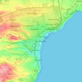
Name: Kirkcaldy topographic map, elevation, terrain.

Location: Kirkcaldy, Fife, Scotland, KY1 1JA, United Kingdom (56.07102 -3.19823 56.15102 -3.11823)

Average elevation: 164 ft

Minimum elevation: -7 ft

Maximum elevation: 607 ft

Other topographic maps

Click on a map to view its topography, its elevation and its terrain.

Dunfermline

United Kingdom > Scotland > Fife > Dunfermline

Average elevation: 262 ft

Aberdour

United Kingdom > Scotland > Fife

Average elevation: 253 ft

Oakley

United Kingdom > Scotland > Fife

Average elevation: 292 ft

Loch Gelly

United Kingdom > Scotland > Fife > Lochgelly

Average elevation: 407 ft

Kinghorn

United Kingdom > Scotland > Fife

Average elevation: 125 ft

Dunfermline

United Kingdom > Scotland > Fife

Average elevation: 374 ft

North Queensferry

United Kingdom > Scotland > Fife

Average elevation: 30 ft

Rosyth

United Kingdom > Scotland > Fife

Average elevation: 75 ft

Auchtertool

United Kingdom > Scotland > Fife

Average elevation: 371 ft

Burntisland

United Kingdom > Scotland > Fife

Average elevation: 161 ft

Townhill Wood

United Kingdom > Scotland > Fife > Dunfermline > Townhill

Average elevation: 453 ft

Cameron Reservoir

United Kingdom > Scotland > Fife

Average elevation: 512 ft

Inchkeith

United Kingdom > Scotland > Fife > Burntisland

Average elevation: 3 ft

Kinghorn Loch

United Kingdom > Scotland > Fife > Kinghorn

Average elevation: 210 ft

Inchcolm

United Kingdom > Scotland > Fife

Average elevation: 3 ft

Loch Ore

United Kingdom > Scotland > Fife > Glencraig > Lochcraig

Average elevation: 374 ft

Isle of May

United Kingdom > Scotland > Fife

Average elevation: 3 ft

Loch Fitty

United Kingdom > Scotland > Fife > Kelty

Average elevation: 499 ft

Mossmorran Pond

United Kingdom > Scotland > Fife > Cowdenbeath

Average elevation: 449 ft

Silver Sands

United Kingdom > Scotland > Fife > Aberdour

Average elevation: 112 ft

Kinghorn

United Kingdom > Scotland > Fife

Average elevation: 125 ft

East Burn

United Kingdom > Scotland > Fife > Kirkcaldy

Average elevation: 144 ft

Denett Burn

United Kingdom > Scotland > Fife > Anstruther

Average elevation: 148 ft

Inverkeithing

United Kingdom > Scotland > Fife

Topographically, Inverkeithing is situated on a raised terrace sloping down towards Inverkeithing Bay, which cuts in to the south of the town, separating it from the North Queensferry peninsula. Its medieval centre lay along High Street and Church Street, but the town has since expanded to encompass areas to…

Average elevation: 92 ft

Rosyth

United Kingdom > Scotland > Fife

Average elevation: 75 ft

Burntisland

United Kingdom > Scotland > Fife

Average elevation: 161 ft

Dunfermline

United Kingdom > Scotland > Fife

Average elevation: 374 ft

Gear up for your next adventure:

🦟Ultrasonic Repellers - Create a bug-free zone at your camp or rest stop
🧭Compass with Lanyard - Easy‑carry compass for navigation
🛶Inflatable Kayak - Portable kayak for rivers, lakes, and expeditions
🎒Day Hiking Backpack - Lightweight backpack perfect for day trips and outdoor adventures
🔥Fast-Boil Camping Stoves - Efficient cooking systems for quick trail meals

As an Amazon Associate, this site earns from qualifying purchases at no extra cost to you.