
Aberdour topographic map
Click on the map to display elevation.
About this map
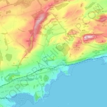
Name: Aberdour topographic map, elevation, terrain.
Location: Aberdour, Fife, Scotland, United Kingdom (56.03180 -3.36162 56.09454 -3.26798)
Average elevation: 253 ft
Minimum elevation: -7 ft
Maximum elevation: 709 ft
Other topographic maps
Click on a map to view its topography, its elevation and its terrain.
Kirkcaldy
United Kingdom > Scotland > Fife
Towards the end of the 16th century, a detailed assessment on the size of the townscape was carried out. The first estimate of the parish population in 1639 was between 3,000 and 3,200 and around 3,400 by 1691. At the beginning of the 18th century, the population declined. A census by Webster's Topographical…
Average elevation: 164 ft
Kellie Castle
United Kingdom > Scotland > Fife > Arncroach > Newton of Balcormo
Average elevation: 226 ft
Kirkcaldy
United Kingdom > Scotland > Fife
Towards the end of the 16th century, a detailed assessment on the size of the townscape was carried out. The first estimate of the parish population in 1639 was between 3,000 and 3,200 and around 3,400 by 1691. At the beginning of the 18th century, the population declined. A census by Webster's Topographical…
Average elevation: 164 ft