
Bamban topographic map
Click on the map to display elevation.
About this map
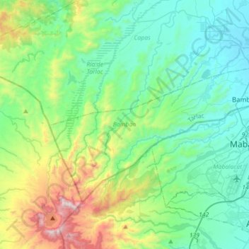
Name: Bamban topographic map, elevation, terrain.
Location: Bamban, Tarlac, Central Luzon, 2317, Philippines (15.16174 120.34739 15.33030 120.62621)
Average elevation: 1,230 ft
Minimum elevation: 157 ft
Maximum elevation: 4,777 ft
Other topographic maps
Click on a map to view its topography, its elevation and its terrain.
Camiling
Mostly of plain topography but some parts are hilly to mountainous in which the barangays of Papaac, Bacsay, Birbira and Cayasan, to name a few. The deeper part of the mountains can be described as a place where wild animals live, such as deer, Toddy cat (Musang), wild boar (Baboy ramo), Monitor lizard…
Average elevation: 105 ft