Make a donation
Gear up for your next adventure:
As an Amazon Associate, this site earns from qualifying purchases at no extra cost to you.
Andagna topographic map
Click on the map to display elevation.
Make a donation
Gear up for your next adventure:
As an Amazon Associate, this site earns from qualifying purchases at no extra cost to you.
About this map
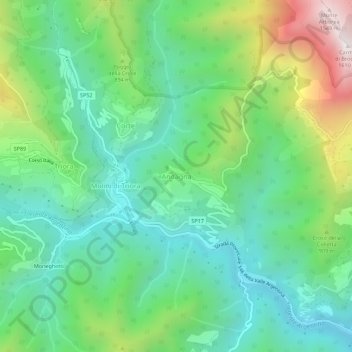
Name: Andagna topographic map, elevation, terrain.
Location: Andagna, Molini di Triora, Provincia di Imperia, Liguria, Italy (43.97136 7.76405 44.01136 7.80405)
Average elevation: 2,382 ft
Minimum elevation: 1,194 ft
Maximum elevation: 5,177 ft
Make a donation
Gear up for your next adventure:
As an Amazon Associate, this site earns from qualifying purchases at no extra cost to you.
Other topographic maps
Click on a map to view its topography, its elevation and its terrain.
Make a donation
Gear up for your next adventure:
As an Amazon Associate, this site earns from qualifying purchases at no extra cost to you.
Make a donation
Gear up for your next adventure:
As an Amazon Associate, this site earns from qualifying purchases at no extra cost to you.
Make a donation
Gear up for your next adventure:
As an Amazon Associate, this site earns from qualifying purchases at no extra cost to you.
Make a donation
Gear up for your next adventure:
As an Amazon Associate, this site earns from qualifying purchases at no extra cost to you.
Make a donation
Gear up for your next adventure:
As an Amazon Associate, this site earns from qualifying purchases at no extra cost to you.
Bajardo
Italy > Liguria > Provincia di Imperia
Its principal settlement, Bajardo itself, is a medieval village which stands at an elevation of 900 metres (3,000 ft) on a peak at the head of the basin of the Nervia torrent.
Average elevation: 2,329 ft
Make a donation
Gear up for your next adventure:
As an Amazon Associate, this site earns from qualifying purchases at no extra cost to you.
Make a donation
Gear up for your next adventure:
As an Amazon Associate, this site earns from qualifying purchases at no extra cost to you.
Bajardo
Italy > Liguria > Provincia di Imperia
Its principal settlement, Bajardo itself, is a medieval village which stands at an elevation of 900 metres (3,000 ft) on a peak at the head of the basin of the Nervia torrent.
Average elevation: 2,329 ft
Make a donation
Gear up for your next adventure:
As an Amazon Associate, this site earns from qualifying purchases at no extra cost to you.
