Geolocate

Forty Four topographic map

Click on the map to display elevation.

About this map

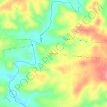
Name: Forty Four topographic map, elevation, terrain.

Location: Forty Four, Izard County, Arkansas, 72585, United States (36.12368 -92.08099 36.16368 -92.04099)

Average elevation: 581 ft

Minimum elevation: 417 ft

Maximum elevation: 774 ft

Izard County trails, hiking, mountain biking, running and outdoor activities

Other topographic maps

Click on a map to view its topography, its elevation and its terrain.

Mount Pleasant

United States > Arkansas > Izard County

Average elevation: 673 ft

Franklin

United States > Arkansas > Izard County

Average elevation: 666 ft

Guion

United States > Arkansas > Izard County

Average elevation: 466 ft

Pineville

United States > Arkansas > Izard County

Average elevation: 653 ft

Melbourne

United States > Arkansas > Izard County

Average elevation: 659 ft

Gear up for your next adventure:

🗺️NatGeo Topo Maps - High-quality waterproof printed topographic maps of US Parks
🥾Hiking Shoes - Durable and comfortable shoes for trail hiking
🦶Hiking Gaiters - Keep debris and water out of your boots
🥾Men's Hiking Boots - Durable, waterproof footwear for rugged terrain and steep inclines
🏫Relief Map Kits - Hands-on tools for teaching landforms and elevation

As an Amazon Associate, this site earns from qualifying purchases at no extra cost to you.