Geolocate

罗城头街道 topographic map

Interactive map

Click on the map to display elevation.

About this map

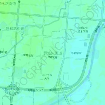
Name: 罗城头街道 topographic map, elevation, terrain.

Location: 罗城头街道, 邯山区, 邯郸市, 河北省, 056000, 中国 (36.56713 114.48371 36.58656 114.51205)

Average elevation: 197 ft

Minimum elevation: 184 ft

Maximum elevation: 210 ft

Other topographic maps

Click on a map to view its topography, its elevation and its terrain.

武安市

中国 > 河北省 > 邯郸市

武安市, 邯郸市, 河北省, 056000, 中国

Average elevation: 1,394 ft

彭城镇

中国 > 河北省 > 邯郸市

彭城镇, 邯郸市, 河北省, 056000, 中国

Average elevation: 650 ft

古武当山景区

中国 > 河北省 > 邯郸市

古武当山景区, 摩天仙桥, 武安市, 邯郸市, 河北省, 056000, 中国

Average elevation: 3,051 ft

青崖寨

中国 > 河北省 > 邯郸市

青崖寨, 邯郸市, 河北省, 056000, 中国

Average elevation: 4,865 ft

通头村

中国 > 河北省 > 邯郸市

通头村, 邯郸市, 河北省, 056000, 中国

Average elevation: 253 ft

平村

中国 > 河北省 > 邯郸市

平村, 邯郸市, 河北省, 056000, 中国

Average elevation: 171 ft

车谷水库

中国 > 河北省 > 邯郸市

车谷水库, 武安市, 邯郸市, 河北省, 056000, 中国

Average elevation: 2,674 ft

娄里村

中国 > 河北省 > 邯郸市

娄里村, 邯郸市, 河北省, 056000, 中国

Average elevation: 348 ft

北张庄镇

中国 > 河北省 > 邯郸市

北张庄镇, 邯山区, 邯郸市, 河北省, 056000, 中国

Average elevation: 236 ft

永年区

中国 > 河北省 > 邯郸市

永年区, 邯郸市, 河北省, 057100, 中国

Average elevation: 190 ft

丛台区

中国 > 河北省 > 邯郸市

丛台区, 邯郸市, 河北省, 056100, 中国

Average elevation: 210 ft

磁山镇

中国 > 河北省 > 邯郸市

磁山镇, 邯郸市, 河北省, 056000, 中国

Average elevation: 961 ft

霍庄村

中国 > 河北省 > 邯郸市

霍庄村, 邯郸市, 河北省, 056000, 中国

Average elevation: 131 ft

大名县

中国 > 河北省 > 邯郸市

大名县, 河北省, 中国

Average elevation: 151 ft

成安县

中国 > 河北省 > 邯郸市

成安县, 河北省, 056700, 中国

Average elevation: 194 ft

肥乡区

中国 > 河北省 > 邯郸市

肥乡区, 邯郸市, 河北省, 057500, 中国

Average elevation: 161 ft

临漳县

中国 > 河北省 > 邯郸市

临漳县, 河北省, 056600, 中国

Average elevation: 223 ft